MP Board Class 9th Social Science Solutions Chapter 15 Growth of Rural Economy
MP Board Class 9th Social Science Chapter 15 Text Book Questions
Choose the Correct Answer:
Question 1.
Who owns resources in a capitalistic economy?
(a) Government
(b) Both
(c) Individual
(d) None of the above.
Answer:
(c) Individual
Question 2.
Which Mughal ruler did give priority to the construct canals to increase irrigation facilities?
(a) Mohammad Tughlaq
(b) Akbar
(b) Shahjailan
(d) Humayun.
Answer:
(a) Mohammad Tughlaq
Question 3.
Before the arrival of Britishers the rural economy was based on –
(a) Currency system
(b) Self-sufficiency
(b) Imports
(d) Exports.
Answer:
(b) Imports
Question 4.
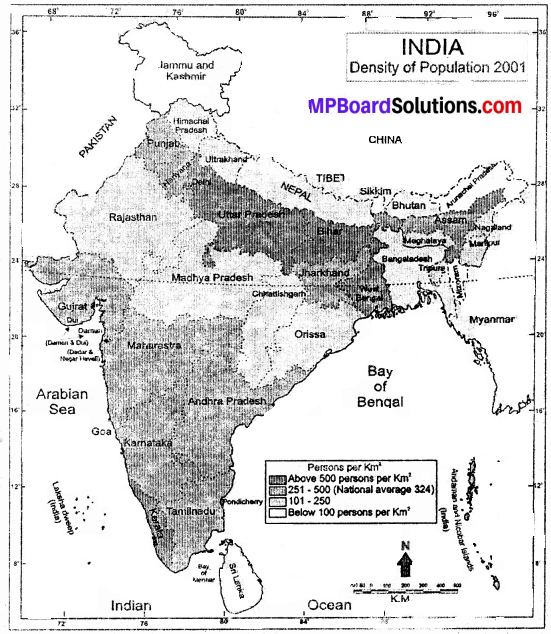
The percentage of rural population India in the year 2001 was –
(a) 21.4
(b) 32.0
(c) 65.1
(d) 72.2.
Answer:
(d) 72.2.
Question 5.
When was land reform introduced in India?
(a) After independence
(b) Before the arrival of Britishers
(c) In vedic period
(d) In Mughal period.
Answer:
(d) In Mughal period.
![]()
Fill in the blank:
- An …………… is a system by which people earn their living.
- Now mainly ………….. crops are produced during a year.
- The primary objective of farming was ……………. before the arrival of the Britishers.
- The zamindari system was started by ………………
Answer:
- economy
- three
- self sufficiency
- Lord Cornwallis.
True or False:
- The government decides a minimum support price for the sale of crops at reasonable price.
- Villages got completely independent after the arrival of the British.
- For the development of agriculture the small non-economic farms should be merged into one big farm.
- Contribution of agriculture in the national income is increasing after independence.
Answer:
- True
- False
- True
- False
![]()
MP Board Class 9th Social Science Chapter 15 Very Short Answer Type Questions
Question 1.
Explain the term ‘economy’.
Answer:
An economy is a system by which people earn their living and it comprises of the production units existing in that area. In other words we can say, an economy of a country includes shops, mines, banks, roads, schools, colleges, universities, hospitals etc. which provide employment to people and produce goods and services which is also used by the people of that place.
Question 2.
How were the village economies in India organised before the arrival of the Britishers?
Answer:
In ancient times majority of population resided in villages. In fact villages were a major unit of the economy. At that time villages were self-sufficient, prosperous and happy. The villagers fulfilled their needs through local resources only.
![]()
Question 3.
What is meant by self – sufficiency of villages?
Answer:
Self – sufficiency means that villagers fulfilled their needs through local resources only before the arrival of the British.
Question 4.
What were the main categories of working population of ancient villages?
Answer:
The main categories of working population of ancient villages were:
- Farmers
- Artisans
- Village officer.
MP Board Class 9th Social Science Chapter 15 Short Answer Type Questions
Question 1.
State the structure of Indian rural working community before the arrival of the Britishers?
Answer:
There were three main components of the working population or community is before the terminal of Britishers Farmers, artisans and village officer.
Farmers:
The most important component of the rural economy was the fainer. The special feature was that every farmer in the village had his own house and share in the land. They were resourceful. Livelihood was the primary objective of farming.
Artisans:
Artisans included carpenters, blacksmiths, potters, goldsmiths, craftsmen, cobblers weavers etc. They fulfilled the needs of villagers in the village itself.
Village Officers:
The village officers were of three types:
- Mead
- Maal Gujar
- Kotwal.
Question 2.
Why did the transfer of land – holding start after the arrival of the Britishers?
Answer:
We know that the Britishers made India their colony and ruled over our country for about 200 years. They exploited India as well as Indians from every point of view. They adopted such policies due to which prosperous India had to face poverty and starvation. Farmers lost their prosperity.
They started meeting their requirements by taking loans due to widespread poverty. But due to the inability to repay loans the moneylenders started confiscating ‘ their land. Thus, the agricultural, land was transferred to the money- v lenders from farmers – As a result the farmers became landless.
Question 3.
Why did’ the Barter system of exchange prevail in India?
Answer:
Before the arrival of the British the villages were self – reliant and self – sufficient. They fulfilled their heeds through local resources. Hence barter system of exchange prevailed in the ancient rural economy. The farmers obtained the required goods and services from artisans and moneylenders and gave them food – grains in exchange. All the payments for the services of pandit doctor, barber, washserman, were made in the forms of grains or other things.
Question 4.
What changes occurred in the structure of rural economy 1 after independence?
Answer:
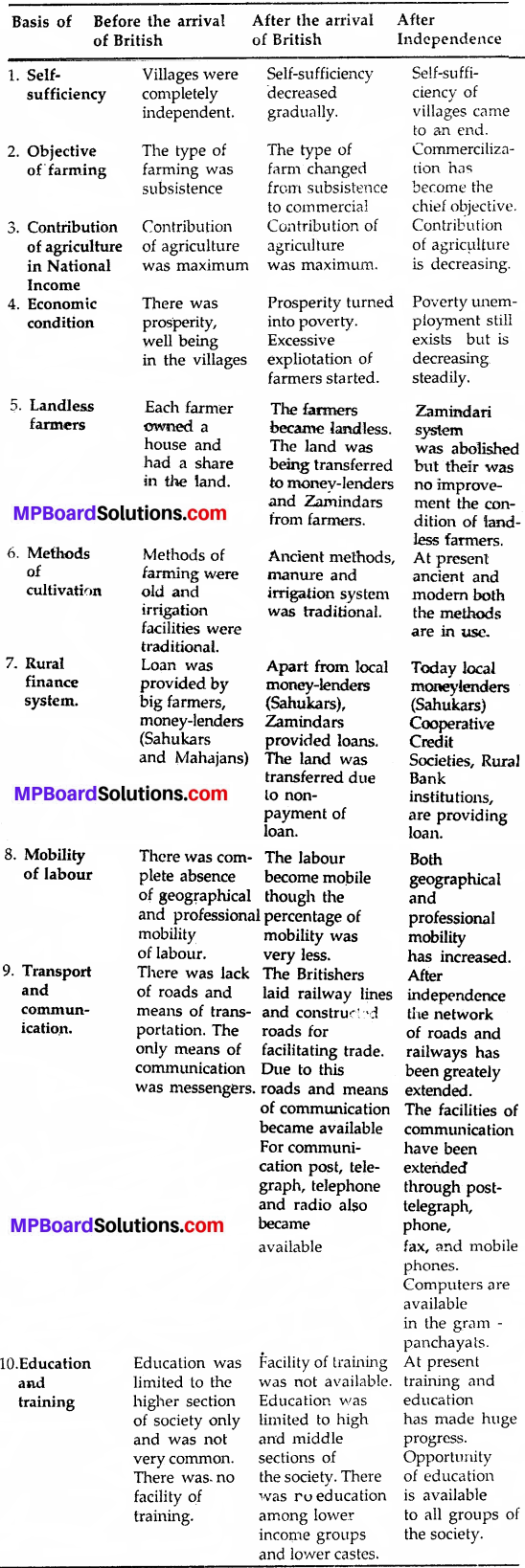
Several changes occurred in the structure of rural economy after independence:
- Structure of community on the basis of availability of land we can divide the farmers into four categories on the basis of ownership of land available to them big farmers, medium farmers, small farmers and landless farmers.
- Multiple cropping Mainly three crops are produced during a year kharif, rabi and jayed.
- Migration of population towards cities – The rural population is fleeing towards urban areas due to poverty, starvation, unemployment etc.
- Rise of monetary system -Barter system is not in existence. Today currency is used everywhere.
- Inadequate facilities of transport and communication In villages, most of the roads are kachha roads. In rainy season many villages are cut off with their nearby village areas.
- Development of subsidiary and cottage industry.
- Institutional changes.
- Extension of education and health facilities in India.
![]()
Question 5.
Why did the population migrate from villages to cities?
Answer:
The Britishers exploited India as well as Indians from every point of view. They adopted such policies due to which prosperous villagers had to face poverty and starvation. They became prey to unemployment and lack of basic facilities. As a result they began to flee towards cities in pursuit of a better life.
MP Board Class 9th Social Science Chapter 15 Long Answer Type Questions
Question l.
Write about the characteristics of ancient rural economy of India.
Answer:
Characteristics of ancient rural economy are given below:
Self – sufficiency:
Villages were self-reliant and self – sufficient. Self – sufficiency means that villagers fulfilled their needs through local resources only. It was possible because of two reasons. First the needs of villagers were limited and second there was lack of the means of transport and communication.
Barter System:
Barter system of exchange was prevalent in the ancient rural economy. The farmers obtained the required goods and services from artisans and money – lenders and gave them food – grains in exchange. All the payments for the services of pandit, doctor, barber, washer – man were made in the form of grains or other things.
Simple Division of Labor Economic activities were divided. The division of work was heredity or based on tradition as farming and animal husbandry, and on caste or in accordance to traditions blacksmith, goldsmith, carpenters, cobbler, barber, washer-man etc. This division of labor was absolutely simple. , Immobility of Labor It was a significant characteristic of ancient economy.
Due to lack of means of transport, caste system, problem of language and food habits, laborers used to stay in their villages. Generally ’they did not go out of their villages. Indifferent Attitude Towards State: The villagers were not interested in the activities of the state.
![]()
Question 2.
What efforts did the government take for the development of rural economy after independence?
Answer:
From the very beginning, Central Government and State Government have endeavored’ for the development of villages and village economy through five year plans and have achieved enough success. But, a lot of work is still to be accomplished.
The government emphasized on the public participation for the development programmers through self – help groups and Panchayati Raj institutions. The government efforts can be explained on the basis of the following points:
1. Land Reforms:
Through the abolition of Zamindari system, land ceiling, land consolidation and by bringing cultivable wasteland under cultivation uneconomic land holdings have been made profitable.
For restoration of land and to restrict its transfer in , rural areas, the government has distributed the wasteland and land obtained through ceiling of land holdings, and ‘Bhoodan’ among the farmers.
Crop insurance policy has also been introduced. The loan facilities has been provided for the modernization of agriculture by establishing rural banks and government banks for the fulfillment of rural finance. The government decides a minimum support price for the sale of crops at reasonable price.
The facility for storage and marketing is also provided. Efforts have been made to connect all the villages through road network. An aim to connect rural areas throughout the year through roads under the Prime Minister road scheme of Central government has been made.
2. Housing, Cleanliness and Health:
The government has introduced Indira Awas Yojna in villages for healthy hopsing system ‘ in place of unhealthy housing system. The Central rural cleanliness programmer contributed a lot for the cleanliness of rural areas. It has some other aspects also to bring quality to life and to provide, dignity to women.
Attention is also being paid towards cleanliness. of drinking water and basic needs in schools. In villages awareness regarding food, health, and education is being spread through family welfare center and Aaganwadi Kendras. Television and Radio are also, playing an important role in this work.
3. Cottage and Small Scale Industries:
Cottage and small; scale industries play a significant role for the development of rural areas. The government is continuously making efforts to develop them in rural areas. Such as
(1) Government has established special institutions to solve the problems of these industries. All India Board of Handloom Industry, Indian Cottage Industry, Khadi Gramudhyog etc are examples of these type of institutions.
(2) Bhartiya Laghu Udhyog is established for financial help.
(3) The government departments give preference to these sector over Gather sector in making purchase of goods produced by small scale industries. Apart from this, fare, exhibition, temporary markets are arranged to promote their sale in foreign countries as well as our country.
(4) Training centers have been set up for technical assistance.
(5) Thus by providing various type of protection to these industries their competition with large industries has been ruled out. In this manner through the efforts of government all efforts are being made for the upliftment of villages. The ideals of Mahatma Gandhi father of nation have been made the basis and efforts are being made for strengthening the rural economy.
![]()
Question 3.
How do cottage and small industries help in the development of rural economy of India? Explain.
Answer:
From the very beginning, Central Government and State Government have endeavored’ for the development of villages and village economy through five year plans and have achieved enough success. But, a lot of work is still to be accomplished.
The government emphasized on the public participation for the development programmers through self-help groups and Panchayati Raj institutions. The government efforts can be explained on the basis of the following points:
1. Land Reforms:
Through the abolition of Zamindari system, land ceiling, land consolidation and by bringing cultivable wasteland under cultivation uneconomic land holdings have been made profitable. For restoration of land and to restrict its transfer in , rural areas, the government has distributed the wasteland and land obtained through ceiling of land holdings, and ‘Bhoodan’ among the farmers.
Crop insurance policy has also been introduced. The loan facilities has been provided for the modernization of agriculture by establishing rural banks and government banks for the fulfillment of rural finance. The government decides a minimum support price; for the sale of crops at reasonable price.
The facility for storage and marketing is also provided. Efforts have been made to connect all the villages through road network. An aim to connect rural areas throughout the year through roads under the Prime Minister road scheme of Central government has been made.
2. Housing, Cleanliness and Health:
The government has introduced Indira Awas Yojna in villages for healthy hopsing system ‘ in place of unhealthy housing system. The Central rural cleanliness programmer contributed a lot for the cleanliness of rural areas. It has some other aspects also to bring quality to life and to provide, dignity to women. Attention is also being paid towards cleanliness. of drinking water and basic needs in schools.
In villages awareness regarding food, health, and education is being spread through family welfare center and Aaganwadi Kendras. Television and Radio are also, playing an important role in this work.
3. Cottage and Small Scale Industries:
Cottage and small; scale industries play a significant role for the development of rural areas. The government is continuously making efforts to develop them in rural areas. Such as
(1) Government has established special institutions to solve the problems of these industries. All India Board of Hand-loom Industry, Indian Cottage Industry, Khadi Gramudhyog etc are examples of these type of institutions.
(2) Bhartiya Laghu Udhyog is established for financial help.
(3) The government departments give preference to these sector over Gather sector in making purchase of goods produced by small scale industries. Apart from this, fare, exhibition, temporary markets are arranged to promote their sale in foreign countries as well as our country.
(4) Training centers have been set up for technical assistance.
(5) Thus by providing various type of protection to these industries their competition with large industries has been ruled out. In this manner through the efforts of government all efforts are being made for the upliftment of villages. The ideals of Mahatma Gandhi father of nation have been made the basis and efforts are being made for strengthening the rural economy.
![]()
Question 4.
Give a comparative study of rural and modern economy.
Answer:
A comparative study of rural and modern economy:
Thus at present villages and villagers both have developed sufficiently. Most important fact is the awareness among the villagers. As soon as they get the resources, they become active for the welfare of themselves and their families. They have knowledge and understanding of education, training, health, cleanliness and politics. Awareness leads to increase in involvement and co-operation of people which ensures the success of plans.
Question 5.
What are the characteristics of an ‘ideal village?’ Explain.
Answer:
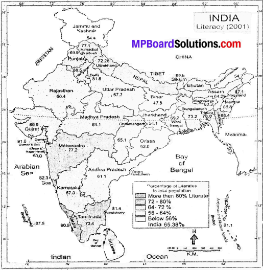
The important heritage of a country is its land and the people residing is it. The spirit of India is in its villages. This is a country of villages. Today 72% of population resides in rural areas. But the condition of villages is not good. Village reform is essential to make the country a leading country. We will have to make our villages ideal villages. An ideal village should have the following characteristics:
1. Advanced Agricultural System:
For the development of agriculture the small non-economic farms should be merged into- one big farm. Consolidation of land should be adopted. Group farming, use of bio and chemical fertilizers to increase the quality of crop, use of high yielding variety seeds and modern facilities of irrigation should be in practice. There should be proper arrangements for storage of crops and sale of crops through cooperatives and government assistance.
2. Housing Facilities:
In villages there should be proper facilities of housing. The houses should be clean whether they are kuchcha or pucca and along with this there should be toilets arid bathrooms within the houses. There should be separate space for \ animals and a proper system of preparing bio-gas by collecting cow dung.
3. Drinking Water Facilities:
The wells, tanks and pucca well with steps should be renovated for clean and safe drinking water. Arrangements should be such that no villager can dump waste into it. Attention should be paid for raising underground water in villages. Thus in villages there should be arrangements for proper drinking water for villagers.
4. Health Facilities:
In every village, there should be primary health centers, as well as doctors and medicines so that the problems of villagers can be solved at the village level itself. The villagers can avail the benefits of the government plans regarding health.
5. Education Facilities:
Efforts should be made to educate each and every child of the village. There should be awareness among villagers for education of girls. There should be provision of adult education in villages along with traditional education. Nutritive and clean mid-day meal should be provided.
6. Facilities of Transportation:
For proper facility of transport there should be roads in villages so that’ it can be connected with nearby villages, small towns and district headquarters. Roads should be such that they can be used in all seasons by all people.
7. Communication Facilities:
There should be proper provision for communication facilities; telephone, post offices, internet facilities should be available.
8. Awareness towards Energy and Environment:
There should be a provision of electricity for power in villages. If possible alternative energy should be used. There should be awareness among villagers towards their environment.
Such a system should be; developed by which the villagers use the refuse in a proper way, and if possible recycle it. Villagers should be active towards the; use of trees and plantation so» that greenery spreads in villages.
9. Industrial Development:
The agrobased industries should be developed in village for example dairy industry, poultry industry etc. Cottage industry should be developed in villages through which villagers can get employment in their own villages and their income can also be increased.
10. Administrative System:
We have a system of Panchayats in our villages. The members of Gram Panchayat. and Sarpanch should be aware and active for the development of villages so that the facilities of cleanliness, drinking water, health and security can be made available to villages. Administrative transparency should, be increased.
The employees of each office in which village secretariat, Panchayat Bhawan, Aaganwadi, Cooperative Societies and School buildings are included should be motivated to keep their offices clean. The name of buildings should be written permanently.
11. Facility of Finance:
The villagers mainly depend on local moneylenders for finance who often exploit them. In an ideal village, facilities of rural banks and co-operative banks should be provided, so that villagers may have facilities of finance. The saving habits in’ villagers can be increased by making them aware towards self-help groups.
![]()
Question 6.
Discuss the efforts which are needed to make a village self-sufficient and developed.
Answer:
The important heritage of a country is its land and the people residing is it. The spirit of India is in its villages. This is a country of villages. Today 72% of population resides in rural areas. But the condition of villages is not good. Village reform is essential to make the country a leading country. We will have to make our villages ideal villages. An ideal village should have the following characteristics:
1. Advanced Agricultural System:
For the development of agriculture the small non-economic farms should be merged into- one big farm. Consolidation of land should be adopted. Group farming, use of bio and chemical fertilizers to increase the quality of crop, use of high yielding variety seeds and modern facilities of irrigation should be in practice. There should be proper arrangements for storage of crops and sale of crops through cooperatives and government assistance.
2. Housing Facilities:
In villages there should be proper facilities of housing. The houses should be clean whether they are kuchcha or pucca and along with this there should be toilets arid bathrooms within the houses. There should be separate space for \ animals and a proper system of preparing biogas by collecting cow dung.
3. Drinking Water Facilities:
The wells, tanks and pucca well with steps should be renovated for clean and safe drinking water. Arrangements should be such that no villager can dump waste into it. Attention should be paid for raising underground water in villages. Thus in villages there should be arrangements for proper drinking water for villagers.
4. Health Facilities:
In every village, there should be primary health centers, as well as doctors and medicines so that the problems of villagers can be solved at the village level itself. The villagers can avail the benefits of the government plans regarding health.
5. Education Facilities:
Efforts should be made to educate each and every child of the village. There should be awareness among villagers for education of girls. There should be provision of adult education in villages along with traditional education. Nutritive and clean mid-day meal should be provided.
6. Facilities of Transportation:
For proper facility of transport there should be roads in villages so that it can be connected with nearby villages, small towns and district headquarters. Roads should be such that they can be used in all seasons by all people.
7. Communication Facilities:
There should be proper provision for communication facilities; telephone, post offices, internet facilities should be available.
8. Awareness towards Energy and Environment:
There should be a provision of electricity for power in villages. If possible alternative energy should be used. There should be awareness among villagers towards their environment.
Such a system should be developed by which the villagers use the refuse in a proper way, and if possible recycle it. Villagers should be active towards the; use of trees and plantation so» that greenery spreads in villages.
9. Industrial Development:
The agrobased industries should be developed in village for example dairy industry, poultry ‘ industry etc. Cottage industry should be developed in villages through which villagers can get employment in their own villages and their income can also be increased.
10. Administrative System:
We have a system of Panchayats in our villages. The members of Gram Panchayat. and Sarpanch should be aware and active for the development of villages so that the facilities of cleanliness, drinking water, health and security can be made available to villages. Administrative transparency should, be increased.
The employees of each office in which village secretariat, Panchayat Bhawan, Aaganwadi, Cooperative Societies and School buildings are included should be motivated to keep their offices clean. The name of buildings should be written permanently.
11. Facility of Finance:
The villagers mainly depend on local moneylenders for finance who often exploit them. In an ideal village, facilities of rural banks and co-operative banks should be provided, so that villagers may have facilities of finance. The saving habits in’ villagers can be increased by making them aware towards self-help groups.
![]()
MP Board Class 9th Social Science Chapter 15 Other Important Questions
Choose the correct answer:
Question 1.
Measurement of land was done by –
(a) Mohammad Tughlaq
(b) Sher Shah Suri
(c) Jehangr
(d) Shahjahan.
Answer:
(b) Sher Shah Suri
Question 2.
The working population in ancient time was divided into –
(a) Farmers and artisans
(b) Farmers, carpenters and landlords
(c) Farmers, artisans and village officer
(d) Farmer, landlord.
Answer:
(c) Farmers, artisans and village officer
Question 3.
The chief officer of the village was –
(a) Plead
(b) Maal Gujar
(c) Kotwal
(d) Panchayat.
Answer:
(a) Plead
Question 4.
The total population of India that resides in urban areas according to 2001 census is –
(a) 72.2%
(b) 27.8%
(c) 30.2%
(d) 19.2%.
Answer:
(b) 27.8%
Question 5.
Kharif crops are crops of –
(a) Winter season
(b) Summer season
(c) Rainy season
(d) Autumn season.
Answer:
(c) Rainy season
Fill in the blank:
- ……………. controls the resources in socialistic economy.
- India is an …………….. country.
- Exchange of goods in called ………………
- In Bengal the Zamindari system was introduced in 1793 by ………………
- Small farmers own less than …………….. hectares of land.
Answer:
- Government
- agricultural
- Barter system
- Lord Cornwallis
- 2.
True or False:
- Before the arrival of Britishers, the rural economy was based on imports.
- During Akbaris Srign Todarmal got the measurement of land done in an accurate manner.
- In the ancient rural economy there was Bartor system.
- Joyed is an annual crop.
- India has 6,00,000 number of villages today.
Answer:
- False
- True
- False
- True
- True.
![]()
MP Board Class 9th Social Science Chapter 15 Very Short Answer Type Questions
Question 1.
Why did Mohammad Tughlaq construct canals?
Answer:
Mohammad Tughlaq constructed canals to increase facilities of irrigation.
Question 2.
Mention the two categories of Indian economy.
Answer:
Rural economy and urban economy.
Question 3.
In which three parts can Indian rural economy be divided?
Answer:
- Rural economy before the arrival of the British.
- Rural economy after the arrival of British.
- Rural economy of Britisher after the independence.
Question 4.
Who were the artisans?
Answer:
Carpenters, blacksmiths, potters, goldsmiths, craftsmen, cobblers, weavers etc. were the artisans.
Question 5.
What did they do for the villagers? What did they get in return?
Answer:
They fulfilled the needs of villagers in the village itself. The remuneration of their work was paid in the form of grain or commodities.
Question 6.
Who kept the record of land revenue?
Answer:
Maal Gujar kept the record of land revenue.
![]()
Question 7.
What do you mean by ‘Barter System’?
Answer:
Barter System of exchange was a system of exchange in which goods were exchanged directly with goods or services. Money was not used in it.
Question 8.
What do you mean by ‘big farmers’?
Answer:
‘Big farmers’ means those farmers who own land up to 2 -10 hectares.
Question 9.
With which season is jayed crop associated?
Answer:
Jayed crop is associated with summer season.
Question 10.
Who are ‘small farmers’?
Answer:
‘Small farmers’ are those who own less than 2 hectares of land.
![]()
MP Board Class 9th Social Science Chapter 15 Short Answer Type Questions
Question 1.
What were the characteristics of rural economy before the arrival of the British?
Answer:
Following were the characteristics of rural economy before the arrival of the British:
- Structure of rural working community
- Self-Sufficiency
- Barter System
- Simple division of labor
- Immobility of labor
- Lack of contact with the outer world.
- Indifferent attitude towards the state.
Question 2.
What were the three types of the village officers?
Answer:
The village officers were of three types:
1. Head:
He was the chief officer of the village and was liable to collect the rent from the farmers and then pay it to the ruler.
2. Maal Gujar:
He was the record keepers of land revenue.
3. Kotwal:
He informed about criminals and provided other important information to the ruler.
Question 3.
What changes were seen in the structure of economy after the arrival of Britishers?
Answer:
The Britishers affected agriculture and industry adverse and the nature of Indian economy also underwent a change. Following changes were – seen in the structure of the economy:
- Decline of workmanship and handicraft.
- Change in the structure of rural community
- End to self – sufficiency of villages.
- Transfer of agricultural land
- Backwardness of agriculture.
Question 4.
What are the characteristics of an ideal village?
Answer:
Village reform is essential to make the country a leading country. We will have to make our villagers ideal villages. In an ideal village agriculture, should be developed and there should be proper arrangement for education, health and housing. In the village there should be awareness towards cleanliness and complete use of available resources.
Thus, an ideal village should have the following characteristics:
- Advances agriculture system.
- Housing facilities
- Drinking water arrangement
- Health facilities
- Education facilities
- Facility of transport
- Facility of communication
- Awareness towards energy and environment
- Industrial development
- Administrative system
- Financial facilities.
![]()
MP Board Class 9th Social Science Chapter 15 Long Answer Type Questions
Question 1.
Describe in detail the changes that were seen in the structure of Indian economy after the arrival of Britishers?
Answer:
We know that the Britishers made India their colony and ruled over our country for about 200 years. They exploited India as well as Indians from every point of view. They adopted such policies due to which prosperous India had to face poverty and starvation. It affected agriculture and industry adversely and the nature of Indian economy also underwent a change.
Following changes were seen in the structure of the economy:
Decline of Workmanship and Handicraft:
As a result of policies of the British the handicrafts man-ship in Indian villages declined. The artisans of the villages became unemployed. Prosperity and well-being of villages came to an end.
Changes in Structure of Rural Community:
The rural community which was divided into three parts farmers, artisans and village officer. This was now divided into several parts Zamindars, farmers, landlords, land – less farmers, cultivators, agricultural laborers etc. This division was an important reason of backwardness of agriculture.
End to Self – Sufficiency of Villages:
As a result of commercialization of agriculture the crops were transported and sold out of the villages and the required commodities were brought from outside to the villages. Thus, the self-sufficiency of villages ‘came to an end.
Transfer of Agriculture Land:
Farmers started meeting their requirements by taking loans due to widespread poverty. But due to the inability to repay loans the money – lenders started confiscating their land. Thus the agricultural land was transferred to the moneylenders from farmers. As a result the farmers became landless and homeless.
Backwardness of Agriculture:
The Zamindari system started by the English had a bad effect on farmers and farming. The farmers became poor and indebted. Neither the government nor the Zamindars showed interest in the improvement and productivity of land which resulted in the exploitation of farmers and farming.
![]()
Question 2.
What changes were observed in Indian rural economy after independence? Describe in detail.
Answer:
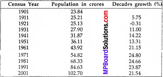
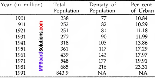
Even after half a century of India’s Independence 72.2 per cent of the total population of India resides in villages and only 27.8 per cent population resides in urban areas according to 2001 census. In the same way the number of villages is 6,38,588 while the number of cities is only 5,161. It means that out of 10 persons, 7 reside in villages. Today also India is a country of villages, and the economy is Agrobased.
\(\frac { 2}{3}\) rd population of the country directly or indirectly depends upon agriculture for their livelihood. But the contribution of agriculture to the gross product of the country is only 26 per cent. Rapid economic growth has taken place through the five year plans and the rural economy is also not left untouched due to this. The form of villages is changing the shape of villages. Several changes are observed in the rural economy. Of those, the chief are as following:
I. The structure of community On the basis of availability of land:
We can divide the farmers into four categories on the basis of ownership of land available to them –
- Big farmers – Who own land up to 2 – 10 hectares.
- Medium farmers – Who own 2 hectare or some more than 2 hectares of land.
- Small farmers – Who own less than 2 hectare of land.
- Landless farmers – Who do not own any land are tenant farmers or are agricultural laborers.
II. Multiple cropping:
Now mainly three corps are produced during a year. Kharif, Rabi and Jayed. Kharif crops are crops of rainy season which are harvested up to September – October. Jayed is crop of summer. Today apart from traditional crops cultivation of cash crops is also practiced for example farming of flower, oil-seeds etc.
1. Migration of Population towards cities:
The rural population is fleeing towards urban areas due to poverty, starvation, unemployment, lack of basic facilities etc. In 1951 out of the total population, the percentage of rural population was 82.7 per cent which came down to 72.2 per cent in 2001 whereas the population in 1951 was 173 which increased to 27.8 in 2001.
2. Rise of Monetary System:
The earlier system of barter prevalent in villages is now almost extinct. Today currency is used everywhere. In the rural areas also money as a medium of exchange is used for buying and selling.
III. Inadequate Facilities of Transport and Communication:
Today a lot of efforts are being made to link all villages through means of transport and communication but most of the roads are Kachcha roads. Therefore in rainy season many villages are cut off with their nearby village areas. Rest of the year truck, bus, train, jeep, motorcycle and cycle are being used. At present villages are also linked by means of television and telephones.
IV. Development of Subsidiary and Cottage Industry:
After independence a lot of attention was paid towards the cottage and small scale industries to make them strong and developed. According to the availability of local raw material in each village cottage industries were developed which has increased employment opportunities and farmers are able to increase their income by working in their free time.
V. Institutional Changes:
Comparatively in very short span of time the farmers in the villages have started adopting new technology. Now pumps are being used instead of ‘Rahat’ for irrigation. The plough is substituted by furrow and bullock cart by truck and tractor trolley. The big machines are being used by big farmers. The use of thresher is very common today.
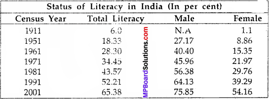
VI. Extension of Education and Health Facilities in India:
The modern villages are generally becoming aware towards education and health. The children of big farmers are acquiring higher education.
In all villages there are primary, middle and higher secondary schools. Girls have also started studying with boys in schools. Health facilities are also available in villages. Through the means of communication also, the villagers are becoming aware of their health.