MP Board Class 9th Social Science Solutions Chapter 10 Medieval India
MP Board Class 9th Social Science Chapter 10 Text Book Questions
Choose the Correct Answer:
Question 1.
Mahmood Ghazani was the ruler of –
(a) Multan
(b) Ghazni
(c) Bahmani
(D) Iraq.
Answer:
(b) Ghazni
Question 2.
The founder of the Slave dynasty was –
(a) Iltutmish
(b) Mohammad Ghori
(c) Qutub-ud-din Aibak
(d) Balban.
Answer:
(c) Qutub-ud-din Aibak
Question 3.
Who injured Ghori in the 1st battle of Tarain –
(a) Prithiviraj
(b) Krishnaraya
(c) Govindraj
(d) Deepakraj.
Answer:
(a) Prithiviraj
Question 4.
Which empire did Harihar and Bukka found –
(a) Bahmani Empire
(b) Vijayanagar Empire
(c) Delhi Sultanate
(D) Mohammad Nagar.
Answer:
(b) Vijayanagar Empire
Question 5.
Who killed Afzal Khan –
(a) Shivaji
(b) Raja Ram
(c) Sahu
(D) Tarabai.
Answer:
(a) Shivaji
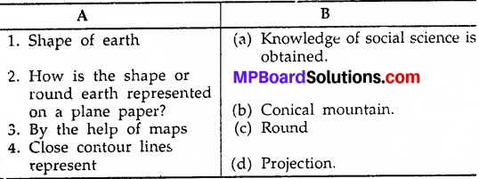
![]()
Fill in the blank:
- The ancient chola rulers have been described in the …………….
- The founder of the Parmor Dynasty was ……………….
- Mahmood Chaznavi made ……………… successful attacks.
- Balban followed the policy of …………………. for regulating his administration.
Answer:
- Sangam literature
- Upendra Raj
- 17
- blood and iron.
True or False:
- The name of Shivaji’s mother was Jijabhi.
- The battle of Haldighati was between Akbar and Rani Durgawati.
- After Jehangir, Shahjahan became the emperor.
- Humayun was the elder son of “Babur”.
- Krishna Dev Rai had write a bok named “Jambvanti Kalyanam. “
Answer:
- True
- False
- True
- True
- True.
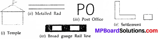
![]()
MP Board Class 9th Social Science Chapter 10 Very Short Answer Type Questions
Question 1.
How many times did Mohammad Ghaznavi attack India?
Answer:
Mohammad Ghaznavi attacked India seventeen times.
Question 2.
Who laid the foundation of Mughal Empire in India?
Answer:
Babur laid the foundation of Mughal Empire in India.
Question 3.
Who founded the Vijayanagar Empire?
Answer:
Two brothers Harihar and Bukka founded the Vijayanagar Empire.
Question 4.
Who was the founder of the Bahmani Empire?
Answer:
The Bahmani Empire was founded by the Muslim Amirs.
Question 5.
Who started the religion “Din-e-Illahi”?
Answer:
Akbar.
![]()
Question 6.
Who was Guru Go-bind Singh?
Answer:
Guru Go-bind Singh was the tenth Guru who organized the Sikhs into a military organization to fight against the Mughal Empire.
MP Board Class 9th Social Science Chapter 10 Short Answer Type Questions
Question 1.
Who was Iltutmish? How did he overcome his difficulties?
Answer:
Iltutmish was one of the most efficient rulers of the Slave dynasty. He was an Ilbari Turk. There were many difficulties in front of Iltutmish after coming to the throne. But he was a great diplomat. He formed a union of the Turks to overcome his difficulties, fie saved Delhi from the attacks of the Mongols.
Iltutmish attacked Ranthambor, Mandor, Nagod, Sambhar, Nayana, Jalore and Gwalior to curtain the rising Rajput power. He won the Gwalior fort in 1232 A.D. Then, due to his foresightedness and diplomacy he overcome all his difficulties.
Question 2.
What was the market policy of Allaudin?
Answer:
Allaudin implemented market control in Delhi. He make goods available to common people on less prices. He also implemented the rationing system. He made Government granaries. Keeping in view the sudden change in the weather, he fixed the rates of goods not on the basis of one’s wishes but in accordance to the cost of production. Excessive taxes were imposed on farmers, traders and Hindus. Taxes were collected strictly.
Question 3.
How did the Tughlaq dynasty establish power over the Delhi Sultanate? Examine.
Answer:
In 1320 A.D. Ghiyasuddin Tughlaq removed the last ruler of the Khilji dynasty. Nisir-ud-din Khusro and became the Sultan of Delhi. He led military campaigns to Warangal, Orissa and Bengal after becoming the Sultan. After Ghiyasuddin, his son Muhammad – bin Tughlaq became the Sultan of Delhi. Firozshah Tughlaq became the next Sultan. After coming to the throne Firoz made successful attacks on Bengal, Jainagar, Nagarkot, Thatta etc.
![]()
Question 4.
Write the contribution of Shershah’s administrative organisation in Indian History.
Answer:
Shershah ruled for a brief period, no doubt, but it has an important place in Indian history. It was because he rekindled the old administrative system with fundamental reforms which proved to be foundation stones for future. Sher Shah gave out most importance to the welfare of the people and laid the foundation of a strong administration, the advantage of which went to the Mughals.
He started many works in the field of military administration, judicial system and land revenue system which was later adopted by Akbar. Shershah divided his empire into Sarkars and Sarkars into Parganas. He made reforms in the currency system.
Question 5.
Write the contribution of Prithviraj Chauhan in Indian history.
Answer:
Prithviraj Chauhan was an able, brave, valiant and powerful emperor. He had a fine army and army commanders. He faced Ghori in 1191 A.D. on the plains of Ta-rain and made him flee. Ghori managed to escape. But again attacked India the very next year. There was another battle in 1192 in which Prithviraj fought valiantly and compelled the forces of Ghori to retreat.
Question 6.
Describe why Maharana Pratap is famous in Indian history.
Answer:
Maharana Pratap’was the brave son of the Rana Udai Singh of Mewar. When all Rajput princes accepted Akbar’s suzerainty, Maharana Pratap did not do so. After the death of Rana Udai Singh, Maharana Pratap fought against Akbar to defend his state.
A very fierce battle was fought on the plains of Haldi Ghati in 1577 A.D. but Rana Pratap was defeated. He fled away from the battle – field. He wandered from forest to forest, ate bread made of grass, but he did not submit to Akbar. He did not accept Akbar’s dominance. This made Maharana Pratap famous in Indian History.
MP Board Class 9th Social Science Chapter 10 Long Answer Type Questions
Question 1.
What were the objectives of Mahmood Ghaznavi’s and Mohammed Ghori’s attack on India. Write the causes of their success.
Answer:
The objectives of Mahmood Ghaznavi’s attack on India:
Mahmood was an ambitious ruler of a small principality of Western Asia. He needed money for his army. He had heard many legends about Indian wealth. In order to plunder India’s wealth, he invaded many parts of northern India from about 1000 to 1027 A.D. Mahmood made seventeen attacks on India. He destroyed many religious places and looted and carried immense wealth to Ghazni.
The Objectives of Muhammad Ghori’s attack on India:
Muhammad Ghori was a ruler of a small principality. Ghori in Afghanistan in the north-west India. Taking advantage of the mutual conflicts of the Indian rulers Ghori first invaded India in nearly 1175 A.D. and brought Multan and Sindh under his domination. The objective of Muhammad Ghori’s invasion on India was acquiring wealth and propagating Islam.
The Causes of their successes:
Both of them were ambitious ruler. They needed money which they acquired by plundering India. After having huge wealth they did what they wished and got wonderful success. They also took advantage of the mutual conflicts of hie contemporary rulers. These rulers lacked political unity which ultimately paved the way to Mahmood Ghaznavi and Muhammad Ghori and they remained successful in achieving their goal.
Question 2.
Describe the administrative organization of King Krishna DavRai and its impact on the people.
Answer:
The most efficient ruler of Tulva dynasty was Krishna DevRai. He was the cousin brother of Veer Narsihma. He was a brave soldier, successful military commander and able administrator. He – established peace in his Kingdom and paid attention towards economic progress.
He crushed the revolts and by defeating the neighboring states made his frontiers secure. He waged successful wars against Bahmani states Orissa, Golconda and Bijapur. He established friendly relations with the Portuguese for political reasons and promotion of trade.
He was an admirer of know Ladge. and art. His court had eight finest poets and artists. Portuguese traveler Peida has praised him a lot. Krishna DevRai himself was a great learner of Telugu and Sanskrit. Pie wrote many books of which Ayukta Malyad and Jambvanti Kalyanam are available even today. Due to his admiration of literature he is also called the ‘Bhoja of Andhra’.
He got Mandaps and Gopurams with hundred pillars constructed in various parts of his Empire. He got Vijay Bhavan, Hazarram temple and Vitthal temple constructed. He also founded a city called Naglapur. Krishna DevRai wanted his people to be happy. He wanted to improve agriculture and promote trade. People were very happy with their ruler. They were satisfied and led a contented life.
![]()
Question 3.
Examine the Rajput and religious policy of Akbar.
Answer:
Akbar’s Rajput Policy:
When Akbar had captured Gwalior, Ajmer and Malwa he came in close contact with the Rajput kingdoms. He was so far-sighted that he saw clearly that he could rule permanently over India, if he made the Rajputs his friends. So he embarked on a definite policy towards the Rajputs. He entered into marriage alliances with many powerful Rajput kingdoms.
Bhara Mai, the ruler of Amber married his younger daughter. He sent his infant prince Dauyal to Amber to be brought up by Bhara Mai’s wives. He gave mans-ab to Bhara Mai and his son. He treated Bhara Mai with great respect and when he dashed to Gujarat in 1572 he placed Bhara Mai in charge of Agra.
Akbar entered into matrimonial relations with a number of other Rajput kingdoms. But he never insisted upon matrimonial relations as a precondition. He gave very high favor to Hadas of Ranthambhore though he did not enter into any matrimonial relations with him.
Akbar’s Rajput policy was combined his religious policy. The Rajput princesses that he married were given full freedom to profess their own religion. The Rajputs who became so related to him became his trusted friends, advisers and his loyal comrades in the battlefield. Bhagwandas and Man Singh were his Rajput generals.
Akbar’s Religious Policy:
Akbar followed a policy of broad religious toleration. He gave full religious freedom to the people. In 1564 he abolished the Jizyah which was used by the Ulema to humiliate the non-Muslims. He abolished the pilgrim’s tax. He gathered at his court a band of talented people and in his Ibadat Khana,
people of all religions:
Christian, Zoroastrians, Hindus, Jains even atheists gathered. He did not like Mullahs who wrangled, shouted, abused each other. He himself read Khutba. He used a royal order called Majhar. He set up a new religion which consisted of many existing religions Hinduism, Christianity, Zoroastrianism etc. This new religion was known as Din-e-Illahi.
By the policy of religious toleration that Akbar followed, he formed a national state in India.
Question 4.
Who were the Indian Kings and rulers who resisted the Mughal power in India and what role did they play? Describe.
Answer:
Babur had laid the foundation of Mughal empire in India in 1526 A.D. by defeating Ibrahim Lodi. The Mughal empire established in 1526 A.D. continues till 1707 A.D. From 1707 A.D.- 1857 A.D. Mughal empire was only nominal in Delhi. From 1526 to 1707 A.D. Babur, Humayun, Akbar, Jehangir, Shahjahan and Aurangzeb followed all methods and tactics, diplomacy and war, friendship ‘ and alliances in order to keep entire India under their sovereignty.
Kings from different parts of India kept challenging them. In order to deal with the problems of the state Hindu Rajput kings had two options Surrender like other Rajput kings in front of Akbar, and become a part of Mughal organization and live a dependent life. Second option was to maintain their independence and defend the glory of their nation.
For following this policy they had to be prepared for fierce wars and leave the pleasures and family life. To protect their values, thoughts and respect of India some Rajput kings decided to’ fight against the Mughals. They gave tough challenge to the Mughal rulers with bravery. The prominent among them were the rulers of Mewir Ran. Sanga, Maharana Pratap, Rani Durgawati of Gond la, Maratha ruler Shivaji, and Sikh leader Govind Singh.
The Ruler of Mewar Maharana Pratap:
Rana Sanga gave stiff resistance in the plains of Khanna. Unfortunately Rana Sanga was defeated. After Rana Sanga Mughal power was resisted by Maharana Udai Singh. After Udai Singh’s death in 1572 A.D. his son Rana Pratap became the ruler of Mewar. He gave a tough challenge to Akbar till he lived.
Rana Pratap started organizing Mewar to give Mughals a fight. He organised feudal lords (Samants) and Bheels. He shifted his residence from Kumbhalgarh to Gogunde so that Akbar could not attack it easily. Through public relations he created awareness against Mughal power.
These efforts brought unity and the entire Mewar rose against the Mughal power. Akbar never liked the independence of Mewar. But Rana Pratap was not ready to accept the suzerainty, friendship or entering into a matrimonial alliance with Akbar. As a result war started between the two. Akbar’s armies conquered Gogunde. But Rana Pratap did not accept defeat. He carried on war against the Mughals and managed to win back many of the lost areas.
Rani Durgawati:
She was a valiant warrior of medieval history. When Akbar heard about the economic prosperity of the Kingdom of Gorha, he sent Asif Khan with a big army to attack on Gorha state for extending his empire. Rani Durgawati decided to fight than surrendering. She bravely fought against the forces of Asaf Khan but in the end she was wounded seriously. When she lost all hopes of winning the battle, she ended her own life.
Chhatrapati Shivaji:
The strongest opposition to the Mughal Empire, was given by Maratha’s under the leadership of Shivaji. Aurangzeb made several plans to trap Shivaji but was not successful. He sent the famous military commander Raja Jai Singh against Shivaji. But nothing happened in the favor of Aurangzeb. When Shivaji went to meet Aurangzeb with Raja Jai Singh, Aurangzeb treacherously imprisoned him. But, Shivaji managed to escape from there which made Aurangzeb extremely angry.
Sikh:
The Sikh also resisted the Mughal power. Guru Govind Singh, the tenth Guru, organized the Sikhs into a military organization to fight against the Mughal armies. He started the practice of prefixing the word ‘Singh’ among Sikhs. Sikh community put challenges in front of the Mughal Empire.
![]()
Question 5.
Write down the causes responsible for the decline of the Mughal Empire.
Answer:
Mughal Empire, the foundation of which was laid by Babur, its decline could be seen from the period of Aurangzeb. After the death of Aurangzeb in 1707 Mughal power declined rapidly. The chief causes of decline of this massive empire were as follows:
Aurangzeb’s Empire, his Policies and War:
Aurangzeb’s responsibility can be placed prominently as a chief of Mughal empires decline. His religious – orthodox policy and anti-Hindu policy was one of the chief cause. Due to his policy of oppression he made Jats, Rajputs, Maratha’s, Sikhs etc. as his enemies.
He oppressed the Hindus due to which he stopped getting the support of the Rajputs. Marathas and Jats gave severe blows to his empire, due to which Mughal Empire declined. To bring the kingdoms of the south under his subordination Aurangzeb fought for 25 years with the different states of South India, in which he had to face severe loss of men and money. These wars shook the foundation of the empire.
Excessive Taxes:
Mughal rulers imposed heavy taxes on the people for their pleasures and wars, paying which became impossible for the people. There were voices of revolt among the common man.
Vastness of Empire:
The vastness of Mughal Empire in and outside India also became a cause of decline of Mughal Empire. A vast Empire could have only been regulated through a centralized authority. Due to weak central authority the Mughal Empire also started breaking up. Akbar had saved the Empire by his diplomacy but his successors were not successful in this.
Revolts of Chieftains and Princes:
Revolts of Loyal Chieftains and Princes also helped in the decline of Mughal Empire. The revolts of royal leaders like Salem, Khusro, Shahjahan and /uirangzeb also gave a blow to the unity of the Empire.
War of Succession:
The war of succession for power also gave a deep wound to the Mughal Empire. There was no certain rule of succession in Muslim royal power. There were many claimants to tire throne due to which the successor was decided on the bayonet point. The war of succession between the sons of Jahangir and among the sons of Shahjahan for power aided the decline of Mughal Empire.
Moral Decline of Mughal Rulers:
Early Mughal rulers were loyal and virtuous towards their state. But the Mughal rulers after Jahangir were pleasure seeking and com-placement.
Religious Policy:
The religious policy of the Mughals was bias. Most of the rulers were staunch followers of Islam. They supported the spread and growth of Islam, whereas harmed other religions and other religion followers, due to which Mughal Empire could not get their support. Rise of Hindu Powers: The rise of new Hindu powers also played a role in the decline of Mughal Empire. Marathas, Jats, Sikhs, Rajputs etc.
reorganized themselves and rose against the Mughal empire which had struck Hindu culture. Continuous wars, autocratic rule decline of military power, moral decline of Amirs (Nobles), groupism and other reasons also aided the decline of Mughal Empire.
![]()
MP Board Class 9th Social Science Chapter 10 Other Important Questions
Choose the correct answer:
Question 1.
Pallavo Kings ruled for nearly –
(a) 500 years
(b) 600 years
(c) 700 years
(d) None of the above.
Answer:
(a) 500 years
(ii) Which one is not a rulers of the Chalukya dynasty?
(a) Pulakesin – I
(b) Pulakesin – II
(c) Vishnuwardhan
(d) Aparajit Varman.
Answer:
(d) Aparajit Varman.
Question 2.
The capital of Pandya Kingdom was –
(a) Mankhet
(b) Trivendrum
(c) Madurai
(d) None of the above.
Answer:
(c) Madurai
Question 3.
Humayun sat on the throne in –
(a) 1530 A.D.
(b) 1540 A.D.
(c) 1630 A.D.
(d) None of the above.
Answer:
(a) 1530 A.D.
Question 4.
Khurram was the son of –
(a) Shahjahan
(b) Jahangir
(c) Akbar
(d) Babur.
Answer:
(b) Jahangir
![]()
Fill in the blank:
- In Mughal Empire ………………. got the land measured.
- Mahmood Ghaznavi attacked India ……………… times.
- TajMahal was built by …………….
- The first battle of Panipat was faught in …………….
- The ruler of Mewar was ………………
Answer:
- Sher Shah Suri
- 17
- Shahjahan
- 152(A.D.)
- Maharana Pratap.
True or False:
- The founder of the slave dynasty was Qutab-ud-Din Aibak.
- The first battle of Ta-rain was fought between Mohammad Ghori and Prithviraj Chauhan.
- Qutab Minor is in Agra.
- Guru Govind Singh started an organization called Khaisa.
- Jaziya Tax was levied on Hindus.
Answer:
- True
- True
- False
- True
- True.
![]()
MP Board Class 9th Social Science Chapter 10 Very Short Answer Type Questions
Question 1.
Which period is referred to as the medieval period?
Answer:
The period between the ancient and modern’ period is referred to as the medieval period.
Question 2.
What happened after the death of Harshavardhan?
Answer:
After the death of Harshavardhan there came a political vacuum in India.
Question 3.
Where did the Chalukya dynasty rule in India?
Answer:
The Chalukya dynasty ruled in southern India.
Question 4.
Name the two Rashtrakuta rulers.
Answer:
Navajo and Dantidurga.
Question 5.
Where was the capital of Rashtrakutas?
Answer:
The capital of Rashtrakutas was at Mankhet.
Question 6.
Who was Atikeshari Marvarman?
Answer:
Atikeshari Marvarman was a famous Pandya ruler.
![]()
Question 7.
Who was the founder of Solanki dynasty of Gujarat?
Answer:
Moolraj was the founder of Solanki dynasty of Gujarat.
Question 8.
Which dynasty later came to be known as the Chauhan dynasty?
Answer:
The Chauhan dynasty later came to be known as the Chauhan dynasty.
Question 9.
Why did Iltutmish appoint his daughter Razia as his successor?
Answer:
The sons of Iltutmish were incapable but his daughter Razia was able Hence Iltutmish appointed her as his successor.
Question 10.
Who established the Khilji dynasty?
Answer:
Sultan Jalal – ud – dirv Khilji established the Khilji dynasty.
Question 11.
What do you know about Sangam dynasty?
Answer:
Vijayanagar was established by two brothers Harihar and Bukka. Their father’s twine was Sangam. Therefore their dynasty came to be known as Sangam dynasty.
Question 12.
What is Tuzukh-i-Baburi?
Answer:
Tuzukh-i-Baburi is a book written by Babur.
![]()
Question 13.
Under whose guardianship did Akbar rule in the beginning?
Answer:
In the beginning Akbar ruled under the guardianship of Bairamkhan.
Question 14.
What do you know about Jazia?
Answer:
Jazia was a tax levied on non – Muslims.
Question 15.
Who abolished Jezia tax?
Answer:
Akbar abolished Jezia tax.
Question 16.
Why were there continuous revolts in Aurangzeb’s Kingdom?
Answer:
Aurangzeb made Rajputs, Jats, Sikhs and Maratha’s his rivals due to which there were continuous revolts in his kingdom.
Question 17.
Who led Akbar’s armies against Rana Pratap?
Answer:
Man Singh led Akbar’s armies against Rana Pratap.
![]()
MP Board Class 9th Social Science Chapter 10 Short Answer Type Questions
Question 1.
Mention the sources of medieval Indian history.
Answer:
We have adequate archaeological and literary sources to study the history of medieval history.
Literary Sources:
- Rajtarangini
- Tuzukh-i-Baburi
- Prithvi Raj Raso
- Padmavat
- Akbarnama etc.
Archaeological Sources:
- Monuments
- Coins
- Copper plates
- Statues
- Temples, Mosques, Miners, Forts
- Paintings and Fresco.
Question 2.
Describe the political vacuum in India after the death of Harshavardhan?
Answer:
After the death of Harshavardhan there was a political vacuum in India. The forces of decentralization led to rise of feudal powers which destroyed the political unity of India. There was rise of new ‘dynasties during this period. For example, Gurjar Pratihars, Pala dynasty, Chalukyas, Parmars and Chauhans in the northern India were the chief dynasties. In southern India Pallavas, Rashtrakutas, Chalukyas of Kalyani, Cheras, Pandyas and Cholas were the chief kingdoms.
Question 3.
Describe the characteristics of Chola administration.
Answer:
The characteristics of Chola administration were:
- King was the highest official of the State.
- Administration was done with the help of Council of Ministers.
- Empire was (divided into provinces, Mandalams, Vala nadus (districs).
- The smallest unit of administration was the Grama and this important unit Grama was divided into 3 parts (assembly of the common people), Sabha (intellecuals) Brahmin, Nagaram (trades, shopkeepers, sculptors). There were several committees for the administrative organization of the Grama.
- Agriculture and trade was well-developed.
- The chief source of states income was land revenue and tax on trade.
- Trade and means of communication were developed’ and there was foreign trade too.
![]()
Question 4.
Describe the ups and downs that came during the reign of Raziva Sultan.
Answer:
The sons of litutmish were incapable therefore he appointed his able daughter Razia as his successor. Raziya sat in the court and lead the wars. Crowning a daughter instead of a son was a novel step’m medieval history – In the whole of medieval period history. Raziya was the first and only Muslim woman Sultan of Delhi Amir Turk Sardars could not tolerate a won’.an Sultan and started conspiring against her and revolting.
The most powerful among the revolts was the one led by Altunia of Bhatinda, Raziya attacked Lahore to crush the revolt. In the war her military commander Yakut was killed and Raziya was murdered. After Raziya Bahram Shah, Alauddin Masood Shah and Nasiruddin Mahmood became the name sake rulers of Delhi Sultanat, while the real power was in the hands of Amir Sardras.
Question 5.
Describe the rise and fall of Bahmani kingdom.
Answer:
After the establishment of Delhi Sultanat in the north, the various states of south remained independent. Due to the difficulties in communication and being located in distant regions the Sultans of Delhi remained away from the politics of south. Alauddin Khilji was the first Sultan of Delhi who established his supremacy over the southern states through force.
‘But after his death Muhammad-bin-Tughlaq established his supremacy over the southern states, but within a short span of time he had to face continuous revolts. During Muhammad Tughlaq’s reign the Muslim Amirs of south revolted and the Bahmani Kingdom was founded. Bahmani Kingdom emerged as a powerful Muslim state.
The foreign Muslim Am/s of south India became angry with the policies, oppression and plans of the Delhi Sultan Muhammad- bin-Tughlaq and revolted. The amies of Sultan were unsuccessful in crushing the revolt. The revolting people established their control over Devgiri.
In about 1357 A.L Hasan Gangu Kohsan Abdul Muzzafar sat on the throne with the name of Alludin Bahman Shah. Bahmani Kingdom remained in south India from 1347 to 1526 A.D, The inefficiency of Sultans, and torture of the people, continuous wars with the neighboring states, struggle between the southern and foreign Amirs, murder of Mahmood Gavan differences between Amirs and other causes hastened the decline of Bahmani kingdom.
![]()
Question 6.
‘Aurangzeb’s reign was full of turmoil Justify it.
Answer:
Aurangzeb’s reign was full of turmoil. Aurangzeb made, Rajputs, Jats, Sikhs and Marathas his rivals due to which there were continuous revolts in the Kingdom. Smvaii encountered him due to his anti-Hindu policy and laid the foundation of an independent Maratha Kingdom.
Sikh Guru Teg Bahadur was killed after torture. After this Guru Gobind Singh organized the Sikh army (Khalsa) to face Aurangzeb. Rajputs like Durgadas Rathor challenged Aurangzeb. Tarabai gave a tough resistance to Aurangzeb for independence of Marathas. Aurangzeb died in 1707 A.D. and with him the decline of Mughal empire also started.
Question 7.
Who were the Sikhs? Write a short account of their emergence as a political power.
Answer:
The Sikhs were the followers of Guru Nanak Dev By the seventeenth century, Sikhism new religion had become the religion of the peasants and artisans in many parts of the Punjab. After Guru Nanak Dev, there were other nine Sikh Gurus. The earlier Gurus concentrated mainly on Sikhism.
But the later Gurus became the military leaders of the Sikhs also. To curb the growing power and strength of .he Sikhs. Aurangzeb ordered the execution of Guru Tegh Bahadur in 1673 A.D. This enraged the.Sikh.
As a result, the tenth and last Guru Govind Singh organised the Sikhs as soldiers and prepared them for a long battle against the Mughals. Like Marathas, the Sikhs; carried out raids in various places, but unlike Marathas, they could not establish an independent state during the reign of Aurangzeb.
MP Board Class 9th Social Science Chapter 10 Long Answer Type Questions
Question 1.
Describe the invasions of Mahmood Ghazni and Mohammad Ghori.
Answer:
Invasions of Mahamood Ghaznavi:
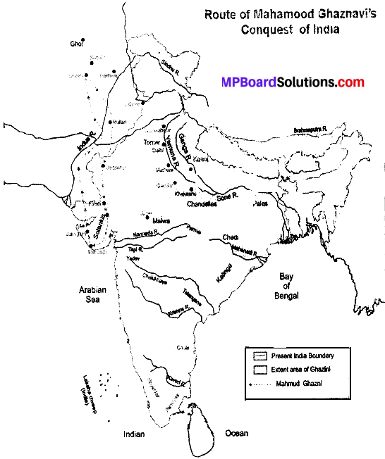
Mahmood was an ambitious ruler of a small principality of Western Asia. He needed money for his army. He had heard many legends about Indian wealth. In order to plunder India’s wealth, he invaded many parts of northern India from about 1000 to 1027 A.D, Mahmood made 17 (seventeen) successful attacks on India.
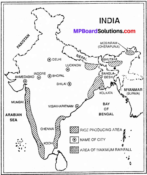
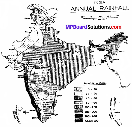
Punjab, Multan, Bhatinda, Nagarkot, Narainpur, Kashmir, Thanesar, Mathura, Kalinjar and Somnath were prominent centres of invasion. Look at the above places on the given, map. Ghaznavi destroyed many religious places and looted and carried immense wealth to Ghazni.
The famous writer Alberuni who came to India with Mahmood Ghaznavi has written about the carnage of Mahmood’s destruction. His attacks led to great economic and cultural loss to the country. The contemporary Hindu rulers faced Mahmood Ghaznavi but were unsuccessful due to lack of political unity. Mahmood Ghaznavi died ir. 1030 A.D. (approx.)
Mohammad Ghori’s invasion:
After 150 years of Mahmood Ghajnavi’s invasion, Mohammad Ghori ruler of a small principality Ghor in Afghanistan in the north-west India; taking advantage of the mutual conflicts of the Indian rulers Ghori first invaded India in nearly 1175 A.D. and brought Multan and Sindh under his domination.
The objective of Mohammad Ghori’s invasion on India was acquiring wealth and propagating Islam. During this time, Hindu states in northern India included – Chauhan state of Delhi and Ajmer Solanki Kingdom in Kannauj, Sena Kingdom in Bengal-Bihar, and Chandel kingdom in Bundelkhand. In southern India Devgiri and Warangal and Hoysal were prominent states.
![]()
Question 2.
Describe the rise of Vijayanagar Kingdom. How did this Kingdom come to an end?
Answer:
The credit for the establishment of Vijayanagar goes to two brothers Harihar and Bukka. Their fathers name was Sangam. Therefore their dynasty is also known as Sangam dynasty. When Muhammed Tughlaq had attacked Warangal and won it, both the brothers were imprisoned and sent to Delhi.
The Sultan was impressed with their ability and service and took them in his army. Both the brothers were sent to South India to crush the revolt. Here they came in contact with the famous Saint Madhav Vidyaranya of South India. Here they were also inspired to protect Hindu Culture. In 1336 A.D; Harihar laid the foundation of Hampi-Hastinavati Kingdom on the southern banks of river Tungabhadra. The city was named Vijayanagar, which later took the form of a big Empire.
Harihar – I:
The first ruler of Vijayanagar was Harihar. He ruled with the help of his brother Bukka and expanded his Empire. In a short span of time he extended his Empire from Krishna river in the north to Kaveri river in the south and till the sea coast in the east and the west. He established a firm administration.
Bukka:
After the death of his brother Harihar he became the ruler of Vijayanagar. Traditional rivalry with Bahmani Kingdom started with Bukkas period. Bukka won the Muslim state of Madurai and expanded his Kingdom to Rameshwaram in farthest-most south.
He did a lot of work for the protection of Hindu culture and took the title of ’Vedmarg-Pratisthan. He gave religious freedom to the believers of Jainism, Buddhism and Islam. He encouraged Telugu literature and centralized administration. He had also sent his ambassador to China.
Harihar – II:
Harihar II became the ruler in about 1377 A.D. He took the title of ‘Maharajadhiraj’. He won the cities of Mysore, Kanijivaram, Chingalpur, Trichnopoly etc. He fought a battle with the Bahmani Kingdom. He invested most of his time in proper organization of administration and religious works.
He got many Hindu temples constructed and donated liberally. Sayan the famous scholar was his Prime Minster. After the death of Harihar II in 1406 A.D. there was a war of succession among his sons Virupaksha – I, Bukka II and Devraya became the rulers. After this Ramchandra and Veer Vijay became the King.
Devraya – II:
Devraya II was the most efficient ruler of Sangam dynastv. There were two terrible wars with Bahmani Kingdom during Devrava’s period in which Vijayanagar had to face severe losses. Devraya attacked Lanka and collected taxes. He promoted sea trade. He patronized literature and Shaivism.
End of Sangria Dynasty:
After Devraya – II Malikarjun (1446-.1465 A.D:) and Virupaksha II (1465-1485 A.D.) were weak rulers. In the end, the feudal leader of Chandragiri Narsingh Sulva in around 1486 A.D. established his control over the Kingdom and laid the foundation of Sulva dynasty” in Vijaynagar.
![]()
Question 3.
Describe the administrative organization of Vijayanagar.
Answer:
The form of administration of Vijayanagar Empire was despotic monarchy. Tire powers of the king were uncontrolled and unlimited. The basis of the state was Hindu religion. The administration of Vijayanagar was divided into Central, provincial and local administration. In the Central administration of Vijayanagar the Emperor, minister Council, Kings assembly, Prince played an important role.
The Emperor had the chief position in the State and was called the Raja, All powers of the state were concentrated in his hands. He himself administered the state. Declaration of war and treaty, appointment of officers and workers organization of law and justice etc. were in his hands. There was a central secretariat for the administration of the state in which there were various departments – Chairman, secretaries and officers.
The officials and workers of the state received land in lieu of salaries. This arrangement was called the Naykat arrangement. Military officials were also given cultivable land. Military officers were called Nayak and the land that was given was called Amaram. The king was the highest judge for the administration of justice. He himself appointed the judges. Provincial officers (Prantapati) in the provinces and Panchayats in the village administered justice.
No delay was done in the administration of justice. Hindu code of justice was prevalent. The laws of criminal cases (Faujdari) were severe. Amputation of hands feet and death punishment were mostly given. The state made,efforts for the development of agriculture and irrigation. Spices were exported. The state encouraged irrigation work.
The construction of canals and ponds was considered to be a noble deed. The land revenue was determined according to the fertility of the land. Land revenue was not uniform throughout the state. Grazing tax, marriage tax, property tax, tax on trade, garden tax, tax on handicrafts were improved by the State. The subjects were happy in spite of heavy taxation.
Provincial Administration:
The Empire was divided into Provinces. Provinces were divided into Kottans or Valanadus. Kottam was a district which was divided into Nadus. Nadus were divided into cities. Village was the smallest unit of the state.The responsibility,of the province was in the hands of a member of the royal family or powerful feudal lord.
Local Administration:
The smallest unit of administration was the village. There was representative body (Pratinidhi Sabha) for the administration of the village which had the representatives of the village. The Pradhan (Chief) of the Gram Panchayat was called Iyengar. He was also given some powers of justice and punishment. He also collected royal taxes. Gram Sabha could donate or sell the land under it. Gram Sabha was given the power to decide some diwani (revenue) and Faujdari (criminal) cases.