MP Board Class 9th Social Science Solutions Chapter 3 India: Location and Physical Divisions
MP Board Class 9th Social Science Chapter 3 Text Book Questions
Choose the Correct – Answer:
Question 1.
Standard time of India is calculated from –
(a) 72° E. longitude
(b) 80°30′ W. longitude
(c) 82°30′ E. longitude
(d) 8.5° E. longitude.
Answer:
(c) 82°30′ E. longitude
Question 2.
Tropic of cancer does not pass through which state of India?
(a) Gujarat
(b) Maharashtra
(c) Chhattisgarh
(d) Orissa.
Answer:
(b) Maharashtra
Question 3.
Largest Union Territory of India is –
(a) Andaman Nicobar Islands
(b) Dadra and Nagar Haveli
(c) Lakshadweep
(d) Pondicherry.
Answer:
(a) Andaman Nicobar Islands
Question 4.
Indian Peninsular Plateau is made of which type of rocks?
(a) Metamorphic
(b) Sedimentary
(c) Oldest rock
(d) Granite.
Answer:
(c) Oldest rock
MP Board Class 9th Social Science Chapter 3 Very Short Answer Type Questions
Question 1.
What are the different names of India?
Answer:
The different names of India are Aryavarta, Hindustan and Bharat.,
Question 2.
What is the area of India?
Answer:
The area of India is 3’2,87,263 km2.
Question 3.
How many States and Union territories are there in India?
Answer:
India is a union of 28 states and 7 union territories.
Question 4.
Name two neighboring island countries of India.
Answer:
Srilanka and Maldives.
![]()
Question 5.
Name any two lakes situated on the East Coast of India.
Answer:
Chilka and Pullical Lakes.
Question 6.
Which islands of India are formed by Corals?
Answer:
Laksha dweep islands of India are formed by corals.
Question 7.
Name two important peaks of the Himalayan range.
Answer:
Mt. Everest and Kanchanjunga.
Question 8.
What is the West-East extent of India? .
Answer:
West – East extent of India is from 68°7′ West to 97°25′ East.
MP Board Class 9th Social Science Chapter 3 Short Answer Type Questions
Question 1.
Explain the importance of the geographical location of India?
Answer:
The geographical location of India gives it a marked advantage for international trade.
Question 2.
Describe the northern Plain of India.
Answer:
The Great Northern Plain extends from the Punjab Plain in the west to the Brahmaputra Valley in the east. This plain lies to the south of the Himalayas. This plain possesses the alluvial deposits of the Ganga, the Indus and the Satluj etc. These rivers are perennial ones and flow down from the Himalayas. The average elevation of this plain is less than 300 meters above sea-level. The Ganga forms the largest part of it.
This region has rich alluvial soil and abundant water-supply so the means of livelihood are easily available here, and the density of population is the highest. The Punjab Plain forms the other part of the Great Northern Plain. The Brahmaputra Valley in Assam forms’ the eastern part of the Great Northern Plain. It is narrower than the Ganga Plain. It is frequently flooded area.
Question 3.
Describe briefly the Southern Plateau.
Answer:
The Southern Plateau lies to the south of the Indogangetic plain. It is triangular in shape. It is bounded in the north by the Vindhyas and Satpura hills while its eastern and western boundaries are formed by the Eastern and Western Ghats. Its surface is uneven and rocky.
The soil is not as fertile as in the northern plain. Since the Southern Plateau is formed of hard igneous and metamorphic rocks, the soil is black and literate. It is not as fertile as the alluvial soil of north plains. The average height of Southern plateau is about 600 feet. This area comparatively receives less rainfall as it is surrounded by mountains from all around.
![]()
Question 4.
What is the importance of Himalayas for India? Explain.
Answer:
Himalayas are of great importance to India. They not only provide natural frontiers for the country but protect us from the cold winds blowing from the Siberia. They cause rainfall in India and are the source of timber, herbs and many other useful products. Himalayan peaks are snow covered throughout the year.
As such they are the source of important rivers like Ganga, the Indus, the Brahmaputra. These rivers bring along them the rich fertile alluvial soil and deposit the same in the great Northern Plain. These rivers have been used for irrigation and Hyde power and are thus important renewable natural resources.
Question 5.
Differentiate between Bangar and Khadar land.
Bangar Land:
- It is the upland of the Northern Plains made by older deposition. Pebbles are also found here.
- Flood water does not reach here.
- Water level is deep.
- It extends mainly in Punjab and the plains of Uttar Pradesh
Khadar Land:
- It is the lowland of the Northern Plains made by the newer alluvium.
- This land is submerged in flood water.
- Underground water level is high.
- It extends in eastern Uttar Pradesh, Bihar and Bengal.
Question 6.
Describe briefly the east coastal plain.
Answer:
The eastern coastal plain extends in the delta region of rivers Mahanadi, Godavari, Krishna and Kaveri flowing in the Bay of Bengal. Fertile alluvial soil is found here. Chilka, Kolerio and Pullicat lakes are situated on this coast. The northern part of the east coast is known as the Northern Cir-cars and its southern part is called the Coromandel coast.
MP Board Class 9th Social Science Chapter 3 Long Answer Type Questions
Question 1.
Describe the geographical division of India.
Answer:
India can be divided into the following geographical divisions:
- The Northern Mountains
- The Great Northern Plains
- The Peninsular Plateau
- The Coastal Region
- Islands
1. The Northern Mountains:
The Himalayas in the north are the new fold mountains which extend from Kashmir to Arunachal Pradesh in the north of India. Their length is about 2400 km and width varies from 150 to 400 km. The Himalayas have three main ranges:
- The Greater Himalayas,
- The Middle Himalayas or the Himachal
- Shivalik Ranges.
1.The Creator Himalayas or the Inner Himalayas or Himadri:
The Greater Himalayas are series of ranges which are always snow-capped. These ranges contain several high peaks which exceed, 8,000 meters above sea level. Mount Everest is the highest peak (8848 km) among them. In addition to that the Nanga Parbat, Kanchanjunga, Nanda Devi, etc. are some other high peaks. As these ranges remain always covered with snow so they are also called ’Himadri.
2. The Middle Himalayas or the Himachal:
Parallel to the south of the Greater Himalayas lies the rangers known as Middle Himalaya or Himachal. The height of these mountains varies between 3700 meters to 4500 meters and average width is 50 km. The Kashmir Valley and the Kangra and Kullu Valleys of Himachal are situated in these ranges. Pirpanjal and Dhauladhar are important ranges of this area. Hill stations like Shimla, Mussoorie, Nainital and Darjeeling belong to Middle Himalayas.
3. Shivalik Ranges:
These are the foot-hill ranges of Himalayas. They have an average height of 600 meters above the sea level. These ranges are often discontinuous. They have gentle slopes towards the north and steep slopes towards the . south. They represent the latest phase of folding and uplifting of the Himalayas.
In addition to these ranges, tine Zaskar and Ladakh ranges in Kashmir and the Kailash range in Tibet lie beyond the Himalayas. To the North-Eastern side of India lie the Naga, the Mizo and the Lushai hills. These hills are eastern extension of the Himalayas.
2. The Great Northern Plains:
The Great Northern Plains extend from the Punjab Plains m the west to the Brahmaputra valley in the east. This plain lies to the south of the Himalayas. This plain possesses the alluvial deposits of the Ganga, the Indus and the Satluj, etc. These rivers are perennial ones and flow down from the Himalayas. The average elevation of this plain is less than 300 meters above sea-level. The Ganga forms the largest part of it.
This region has rich alluvial soil and abundant water supply. So the means of livelihood are easily available here and the density of population is the highest. The Punjab plains forms the other part of the Great Norhtem Plain. The Brahmaputra valley in Assam forms the eastern part of the Great Northern Plain. It is narrower than the Ganga Plain. It is frequently flood area.
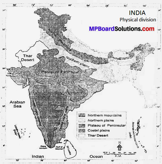
3. The Peninsular Plateau:
The Plateau has the central high lands in the north and the Deccan Plateau in the south. The Narmada Valley divides it into two major sub – divisions. Tire central high lands comprises the Malwa Plateau, the small plateau of Bundelkhand and the Chhotanagpur plateau. The hills of tire Eastern Ghats extend to the west of the Deccan Plateau.
The north western part of the Deccan Plateau in Maharashtra consists of an extensive ‘lava’ belt called the Deccan trap region. The rest of the Deccan Plateau consists of crystalline me tarn opine rocks The coastal plains lie both on the eastern and the western sides of the Deccan Plateau.
The Eastern Coastal Plain is broad. The alluvial delta plains of the Mahanadi, the Godavari, the Krishna and the Kavery are part of the Eastern Coastal Plains. The Western Coastal plain is, however, not so broad. In fact, the Peninsular Plateau is an old stable block or shield which consists of ancient crystalline rocks.
4. The Coastal Plains:
The Deccan Plateau is flanked by the narrow coastal plains along the Arabian Sea and the Bay of Bengal. The coastal plain on the western coast is narrow and uneven. The fast flowing rivers and streams dissect this strip at many places. It covers the plains of Gujarat in the north.
The eastern coastal plain is relatively wide and more level. It consists of some of the most fertile and well watered deltas of Krishna, Godavari, Mahanadi and Kaveri. The western coast has estuaries in the north and lagoons, the salt water lakes in the south particularly in Kerala.
5. Islands:
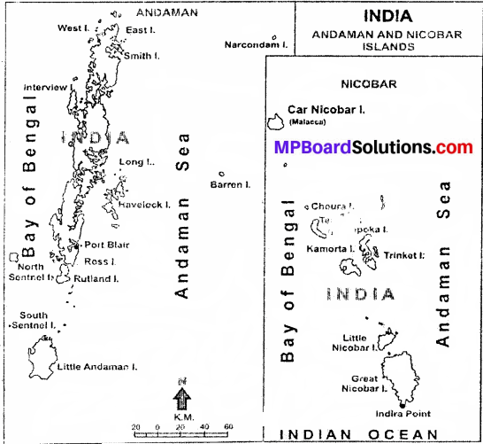
The coral islands off the coast of Kerala are Lakshdweep Island each having area of a few kilometers. This is a horse shoe form of island made by the continuous work of coral polyps. In the eastern parts lie Andaman and Nicobar islands in the Bay of Bengal. Some of these Islands are of volcanic origin and are fairly large in shape.
Question 2.
Describe the location and extent of India.
Answer:
India is situated in Northern Hemisphere in the southern part of the continent Asia. Towards its south lies the Indian Ocean. Bay of Bengal is in the east and Arabian sea is in the west. The latitudinal extent of the main land of India is 8°4′ North to 37°6’ North and the longitudinal extent is from 68°7′ East to 97°25′ East. The Tropic of Cancer (23°30’N) divides the country into almost two equal parts.
82°30′ is the standard meridian for Indian Standard Time. Standard time for the country is calculated from the stairdard meridian. Apart from the main land Andaman Nicobar Islands in the Bay of Bengal and Lakshadweep in the Arabian sea are also part of India. Tropic of Cancer divides the country into almost two equal parts.
Less area of India is situated on the eastern part of the standard meridian. The western c-f the country is Gujarat and the eastern state is Arunachal Pradesh. The northern most state of India is Jammu and Kashmir and the southern most state is Tamilnadu. The extreme southern point of India is located in Andman and Nicobar Islands.
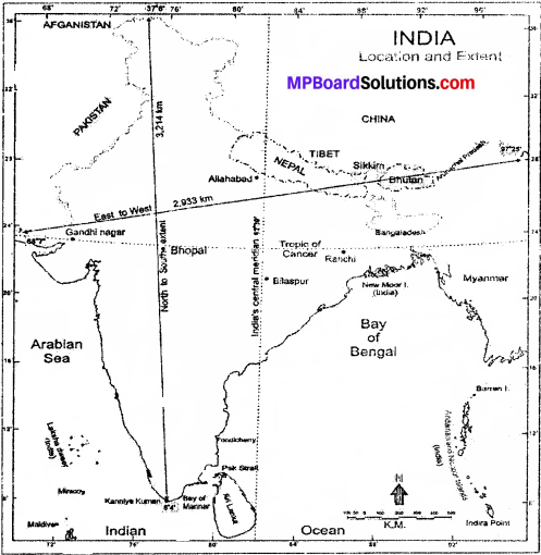
India is bounded by Pakistan, Afghanistan in the north-west, China, Nepai and Bhutan in the north, Bangladesh and Myanmar in the east and Sri Lanka in the South. Palk Straight is between India and Sri Lanka. Coastal Boundaries of India , India is the seventh largest country in the world in regard to area. 2.42% area of the world is in India. India covers an area of 32,87,263 km2.
Question 3.
Describe the Himalayan Mountain Range.
Answer:
India can be divided into the following geographical divisions:
- The Northern Mountains
- The Great Northern Plains.
- The Peninsular Plateau
- The Coastal Region
- Islands.
1. The Northern Mountains:
The Himalyas in the north are the new fold mountains which extend from Kashmir to Arunachal Pradesh in the north of India. Their length is about 2400 km and width varies from 150 to 400 km. The Himalayas have three main ranges:
- The Greater Himalayas,
- The Middle Himalayas or the Himachal
- Shivalik Ranges.
1. The Greater Himalayas or the Inner Himalayas or Himadri:
The Greater Himalayas are series of ranges which are always snow-capped. These ranges contain several high peaks which exceed, 8,000 meters above sea level. Mount Everest is the highest peak (8848 km) among them. In addition to that the Nanga Parbat, Kanchanjunga, Nanda Devi, etc. are some other high peaks. As these ranges remain always covered with snow so they are also called ’Himadri.
2. The Middle Himalayas or the Himachal:
Parallel to the south of the Greater Himalayas lies the rangers known as Middle Himalaya or Himachal. The height of these mountains varies between 3700 meters to 4500 meters and average width is 50 km. The Kashmir Valley and the Kangra and Kullu Valleys of Himachal are situated in these ranges. Pirpanjal and Dhauladhar are important ranges of this area. Hill stations like Shimla, Mussoorie, Nainital and Darjeeling belong to Middle Himalayas.
3. Shivalik Ranges:
These are the foot-hill ranges of Himalayas. They have an average height of 600 meters above the sea level. These ranges are often discontinuous. They have gentle slopes towards the north and steep slopes towards the . south. They represent the latest phase of folding and uplifting of the Himalayas.
In addition to these ranges, tine Zaskar and Ladakh ranges in Kashmir and the Kailash range in Tibet lie beyond the Himalayas. To the North-Eastern side of India lie the Naga, the Mizo and the Lushai hills. These hills are eastern extension of the Himalayas.
2. The Great Northern Plains:
The Great Northern Plains extend from the Punjab Plains m the west to the Brahmaputra valley in the east. This plain lies to the south of the Himalayas. This plain possesses the alluvial deposits of the Ganga, the Indus and the Satluj, etc. These rivers are perennial ones and flow down from the Himalayas. The average elevation of this plain is less than 300 meters above sea-level. The Ganga forms the largest part of it.
This region has rich alluvial soil and abundant water supply. So the means of livelihood are easily available here and the density of population is the highest. The Punjab plains forms the other part of the Great Norhtem Plain. The Brahmaputra valley in Assam forms the eastern part of the Great Northern Plain. It is narrower than the Ganga Plain. It is frequently flood area.
3. The Peninsular Plateau:
The Peninsular Plateau has the central high lands in the north and the Deccan Plateau in the south. The Narmada Valley divides it into two major sub – divisions. Tire central high lands comprises the Malwa Plateau, the small plateau of Bundelkhand and the Chhotanagpur plateau. The hills of tire Eastern Ghats extend to the west of the Deccan Plateau.
The north western part of the Deccan Plateau in Maharashtra consists of an extensive ‘lava’ belt called the Deccan trap region. The rest of the Deccan Plateau consists of crystalline me tarn opine rocks The coastal plains lie both on the eastern and the western sides of the Deccan Plateau.
The Eastern Coastal Plain is broad. The alluvial delta plains of the Mahanadi, the Godavari, the Krishna and the Kavery are part of the Eastern Coastal Plains. The Western Coastal plain is, however, not so broad. In fact, the Peninsular Plateau is an old stable block or shield which consists of ancient crystalline rocks.
4. The Coastal Plains:
The Deccan Plateau is flanked by the narrow coastal plains along the Arabian Sea and the Bay of Bengal. The coastal plain on the western coast is narrow and uneven. The fast flowing rivers and streams dissect this strip at many places. It covers the plains of Gujarat in the north. The eastern coastal plain is relatively wide and more level.
It consists of some of the most fertile and well watered deltas of Krishna, Godavari, Mahanadi and Kaveri. The western coast has estuaries in the north and lagoons, the salt water lakes in the south particulary in Kerala.
5. Islands:
The coral islands off the coast of Kerala are Laksh dweep Island each having area of a few kilometers. This is a horse shoe form of island made by the continuous work of coral polyps. In the eastern parts lie Andaman and Nicobar islands in the Bay of Bengal. Some of these Islands are of volcanic origin and are fairly large in shape.
![]()
Question 4.
Describe the Peninsular Plateau.
Answer:
The Peninsular Plateau is a part of the oldest landmass the Gondwanaland. Its average height from the sea level is 600 to 900 meters. It is surrounded by seas from three sides and by landmass from one side so it is also known as Peninsular Plateau.
It is a triangular plateau with its base in the north, from Delhi, and Rajmahal Hills to northern plain. It is bordered by the Eastern Ghats in the east and by the Western Ghats in the west and Kanya Kumari is at the southern tip. Regarding area, the peninsular plateau is the largest physiographic division of the country.
The peninsular plateau is divided into two parts –
- The Central Highlands.
- The Deccan Plateau.
1. The Central Highlands:
The Northern part of the peninsular plateau comprises of plateaus, uncovered mountain ranges and low mountains. It is made up of hard igneous rocks. In the north-west it is flanked by the Aravallis, which are old folded mountains. On the southern boundary of the Central Highlands lies the Vindhyachal Mountains and it continues to the Kaimur range eastward. The Malwa Plateau lies in between Amrawati and Vindhyachal mountains.
This Plateau is drained by the Betwa, Parvati, Kali Sindh, Chambal and Mahi. The eastern part of the Central Highlands is known as Bundelkhand. The Baghelkhand Plateau is situated in the east of Kaimur Bhander hills. In the central part of Highlands Vindhyachal and Kaimur hills form an escarpment between the valleys of Narmada and Son rivers. The Chhotanagpur Pleteau of Jharkhand is also a part of this region. It is rich in minerals.
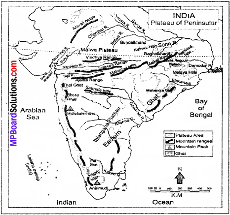
2. The Deccan Plateau:
It extends from Satpura, Mahadev and Maikal hills in the north to the southern tip of peninsula. The north-western part of the plateau is mainly made up of volcanic deposit. The Western Ghats, from the western edge of the Deccan plateau, which run discontinuously from north to south almost parallel to the Arabian Sea. In Maharashtra and Karnataka they are called Shayadri.
The Ghats are crossed by three gaps:
Thalghat, Bhorghat and Palghat. They are called the Nilgiri’s in Tamilnadu and along Kerala and Tamilnadu borders, they are known as Anamalai and Cardamon Hills. Palghat gap separates Nilgiri and Anamalai Hills. The highest peak of Southern India, The Anai Mudi is in Palni Hills. The Eastern Ghat is 800 km. long. Its highest peak is Mahendragir.
![]()
Question 5.
Write Short notes on Indian Coastal Region, Indian Islands.
Answer:
Indian Coastal Region:
The Peninsular Plateau of India from Kutch to Orisa is flanked by a narrow strip of coastal lowlands ‘or plains. Due to difference in their formation, this coastal plain is divided into two parts:
- The West Coastal Plain.
- The East Coastal Plains.
1. The West Coastal Plains:
extends from Gujarat to Kerala along with the Arabian Sea. These.plains are narrow and are known as Konkan in the north and Malabar in the south of Goa. The maximum width here is 40 km. Here the rivers are small and fast flowing. This region has very few major river like Narmada and Tapi. The rivers of the west coast form tire tidal mouth. The coastal plains of Kutch and Gujarat are arid.
2. The East Coastal Plain:
extends in the delta region of rivers Mahanadi, Godavari, Krishna and Kaveri flowing in the Bay of Bengal. Fertile alluvial soil is found here. Chilka, Koleru and Pullicat lakes are situated on this coast, the northern part of the East Coast is known as the Northern Circars and its southern part is called the Coromandel Coast.
Indian Islands:
The coral islands off the coast of Kerala are Lakshadweep Islands each having area of a few kilometers. This is a horse shoe form of island made by the continuous work of coral polyps. In the eastern parts lie the Andaman Nicobar Islands in the Bay of Bengal.
These islands are scattered in a large area and are far away from the main land. These islands are the peaks of sub merged hilly ranges. Some of them are of volcanic origin. There are nearly 300 known and unknown islands in Andaman and Nicobar covering an area of about 8249 km2.
Answer the following questions referring to the Map of India.
Question 1.
Latitude of Northern boundary of India.
Answer:
8°4′ North.
Question 2.
Name the states adjoining China.
Answer:
Arunachal Pradesh, Jammu & Kashmir, Himachal Pradesh, Uttarakhand and Sikkim.
Question 3.
Name the States through which Tropic of cancer pass through.
Answer:
Gujarat, Madhya Pradesh, Chhattishgarh, Jharkhand, West Bengal, Tripura and Mizoram.
Question 4.
Name the rivers which join Bay of Bengal.
Answer:
Ganga, Mahanadi, Krishna, Kaveri, Godavari etc.
Question 5.
Name any three gaps located in Himalayas.
Answer:
Shopkila, Nathula and Bomdila.
True or False:
- Indian ocean is situated in the south of India.
- The seven states of north-west are called “The Seven Sisters”
- The Andman and Nicobar Islands are situated in the Arabian Sea.
- Largest union territory of Indian is Andaman Nicobar Islands.
- The geographical location of India gives it a marked advantage for international trade.
Answer:
- True
- False
- False
- True
- True
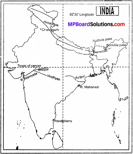
Show the following in the outline map of India.
- Tropic of cancer and 82°30′ E. longitude.
- Union Territory – Chandigarh and Pondicherry.
- Bomdila and Nat-hula passes.
- Raipur and Bhopal
- Narmada River and Mahanadi.
- Himalayas and Vindhyans.
Answer:
Do yourself.
Project Work:
Divide the class in five groups and ask them to prepare a model and give presentation in the class on different physiographic features of India.
![]()
MP Board Class 9th Social Science Chapter 3 Other Important Questions
Choose the correct answer:
Question 1.
The western state of India is
(a) Arunachal Pradesh
(b) Gujarat
(c) Madhya Pradesh.
(d) Kerala
Answer:
(b) Gujarat
Question 2.
The extreme southern point of India is located in –
(a) And man and Nicobar Islands
(b) Lakshadweep
(c) Kerala
(d) None of the above.
Answer:
(a) And man and Nicobar Islands
Question 3.
The width of the Himalayas varies from –
(a) 400 km in Kashmir.to 150 km in Arunachal Pradesh
(b) 200 km in Kashmir to 100 km in Arunachal Pradesh
(c) 500 km in Kashmir to 150 km in Arunachal Pradesh
(d) None of the above
Answer:
(a) 400 km in Kashmir.to 150 km in Arunachal: Pradesh.
Question 4.
Mt. Everest the highest peak in the world is located in –
(a) Sri Lanka
(b) Maldives
(c) Nepal
(d) Himachal
Answer:
(c) Nepal
Question 5.
The Chhotanagpur Plateau is in –
(a) Jharkhand
(b) Bihar
(c) Orissa
(d) Uttarakhand
Answer:
(a) Jharkhand
True or False.
- Tropic of cancer divides India into two equal parts.
- The highest mountain peak in India is Nanda Devi.
- The western state of Indian is Kerala.
- Largest union territory of Indian is Andaman Nicobar Islands.
- The geographical location of India gives it a marked advantage for international trade.
Answers:
- True
- False
- False
- True
- True.
![]()
MP Board Class 9th Social Science Chapter 3 Very Short Answer Type Questions
Question 1.
In which hemisphere does India lie?
Answer:
India is located in the Northern Hemisphere.
Question 2.
Give Geographical location of India.
Answer:
India is situated in the north of Equator. In its south lies a great ocean called Indian Ocean. It is flanked by Pakistan in the West, Myanmar in the East, Bangladesh in East towards Bay of Bengal, China in the North and Sri Lanka in the South.
Question 3.
Name the countries that constitute Indian sub-continent.
Answer:
Pakistan in the north-west, India at the core, Nepal in the north, Bhutan in the north-east.
Question 4.
Name the standard meridian of India.
Answer:
82°5′ east longitude is the standard meridian of India.
Question 5.
Name the largest delta in the Indian sub-continent.
Answer:
The Sundar Ban Delta.
Question 6.
Which is the highest peak in India?
Answer:
The Kanchanjunga in Sikkim was regarded the highest peak in India till Sikkim was not merged with Indian territory,
Question 7.
What are known as the Great Himalayas or Inner- Himalayas or Himadri?
Answer:
The Northern most ranges are known as the Great Himalayas or Inner Himalayas or Himadri.
Question 8.
Name same important passes in Himalayas.
Answer:
Karakoram (Jammu and Kashmir),’Shopkila (Himachal Pradesh), Nathula (Sikkim), Bpmuila (Arunachal Pradesh).
![]()
Question 9.
Define ‘Khadar’ and ‘Bangar’.
Answer:
The region where the flood water reaches every year is known as. ‘Khadar’ and where it does not reach is known as ‘Bangar’.
Question 10.
Where does the Malwa Plateau lie?
Answer:
The Malwa Plateau lies in between Amarawati and Vindhyachal mountains.
Question 11.
What is Maharashtra famous for?
Answer:
Maharashtra is famous for growing cotton.
Question 12.
Name some hill resorts located in plateau region.
Answer:
Ootakmand, Pachmarhi and Mahabaleshwar.
MP Board Class 9th Social Science Chapter 3 Short Answer Type Questions
Question 1.
What is a pass? Name some important passes of Indian Sub-continent?
Answer:
Gaps or openings in a mountain range which provide natural routes to pass through them are called Passes. Though Himalayas provide great barrier for the people to cross through from north but these passes made it possible to cross over. The Indian continent has the following important passes: The Karakoram Pass, The Shipkila Pass, The Nathula Pass, The Bomdila Pass.
![]()
Question 2.
Why is Central plain called the ‘gift of Himalaya’?
Answer:
Central plain covers approximately one-fourth area of India which supports 45% population of the country. This plain is made up of the alluvial soil of Indus, Satluj, Ganga and Brahmputra rivers and have irrigation facilities. Therefore, it is called the ‘gift of Himalaya.
Question 3.
Describe briefly formation of the Northern Plains.
Answer:
Following the formation of the Himalayas, there started the work of mighty rivers and other agents of denudation. This Work or erosion continued for millions of years and ultimately resulting in deposition of silt. Thus, slowly and steadily were formed the Northern Plains. The work of erosion and deposition’ is still going on.
Question 4.
Distinguish between West Coastal Plain and East Coastal Plain.
Answer:
West Coastal Plain:
- They extend along the Arabian Coast.
- This plain is narrow.
- It is formed due to small but fast flowing rivers.
- Deltas are not found on this coast.
East Coastal Plain:
- They extend along the Bay of Bengal.
- This plain is wider.
- It is formed due to the deposition by the rivers Mahanadi, Godavari, Krishna and Kaveri.
- Deltas are found here.
![]()
MP Board Class 9th Social Science Chapter 3 Long Answer Type Questions
Question 1.
Give an account of Deccan Plateau.
Answer:
The Deccan Plateau lies to the south of the Indogangetic plain. It is triangular in shape. It is bounded in the north by the Vindhyas and Satpura hills while its eastern and western boundaries are formed by the Eastern and Western Ghats. Its surface is uneven and rocky.
The soil is not as fertility as in the northern plain. Since the Deccan Plateau is formed of hard igneous and metamorphic rocks, the soil is black and literate. It is not as fertile as the alluvial soil of north plains. The average height of Deccan Plateau is about 600 feet.
This area comparatively receives less rainfall as it is surrounded by mountains from all around. The Krishna, the Godavari, the Mahanadi and Kaveri are the chief rivers. In this region, these rivers are swift and make waterfalls so they are not navigable. These rivers form big deltas at their mouth. The Deccan plateau has a coastal strip in the east and the west. The west coastal plain extends from Gujarat to Kerala.
The coastal strip along the Arabian Sea in the west is known as Konkan in the north and Malabar in the south. In the south, there are south salt water lakes called Lagoons. The coastal strip along the Bay of Bengal is broad and more leveled. The mountain ranges running from north to south along the Arabian sea coast has many names.
In Maharashtra and Karnataka they are called Sahyadri. Further in south, they are called the Nilgiries, in Tamil Nadu along the Kerala and Tamil Nadu border, they are known as Annamalai and Cardamon Hills. The Deccan Plateau is highest along its western edge and slopes towards the Bay of Bengal.