MP Board Class 6th Maths Solutions Chapter 5 प्रारंभिक आकारों को समझना Ex 5.4
पाठ्य-पुस्तक पृष्ठ संख्या # 107-109
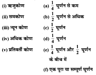
प्रश्न 1.
निम्न के क्या माप हैं :
(i) एक समकोण?
(ii) एक ऋजुकोण ?
हल :
(i) एक समकोण = 90°
(ii) एक ऋजुकोण = 180°
प्रश्न 2.
बताइए सत्य (T) या असत्य (F):
(a) एक न्यून कोण का माप < 90° है।
(b) एक अधिक कोण का माप < 90° है।
(c) एक प्रतिवर्ती कोण का माप < 180° है।
(d) एक सम्पूर्ण घूर्णन का माप = 360° है।
(e) यदि m∠A = 53° और m∠B = 35° है तो m∠A > M∠B है।
उत्तर-
(a) सत्य
(b) असत्य
(c) असत्य
(d) सत्य,
(e) सत्य
प्रश्न 3.
निम्न के माप लिखिए :
(a) कुछ न्यून कोण
(b) कुछ अधिक कोण। (प्रत्येक के दो उदाहरण दीजिए।)
हल :
(a) न्यूनकोण : 60° और 72°
(b) अधिक कोण : 100° और 162°
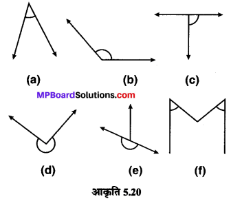
प्रश्न 4.
निम्न कोणों को चाँदे से मापिए और उनके माप लिखिए :
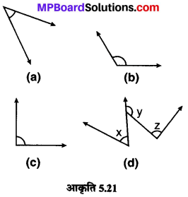
हल :
(a) → 45°,
(b) → 120°,
(c) → 90°,
(d) x = 60°, y = 135°, z = 90°
![]()
प्रश्न 5.
किस कोण का माप बड़ा है ? पहले आकलन (estimate) कीजिए और फिर मापिए।
कोण A का माप
कोण B का माप
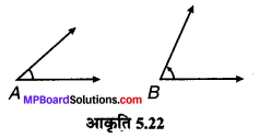
हल :
आकलन से ∠B का माप बड़ा है
मापने पर : ∠A = 40° ; ∠B = 65°
∴ ∠B > ∠A
प्रश्न 6.
निम्न दो कोणों में से किस कोण का माप बड़ा है ? पहले आकलन कीजिए और फिर मापन द्वारा पुष्टि कीजिए।
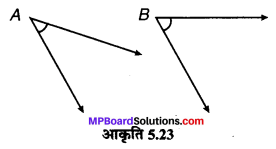
हल :
आकलन से ∠B का माप बड़ा है।
मापने पर : ∠A = 40° ; ∠B = 60°
∴ ∠B > ∠A
प्रश्न 7.
न्यूनकोण, अधिक कोण, समकोण या ऋजुकोण से रिक्त स्थानों को भरिए :
(a) वह कोण, जिसका माप एक समकोण के माप से कम है, ………. होता है।
(b) वह कोण, जिसका माप एक समकोण के माप से अधिक हो, ……….. होता है।
(c) वह कोण जिसका माप दो समकोण के योग के बराबर है,………. होता है।
(d) यदि दो कोणों के मापों का योग समकोण के माप के बराबर है, तो प्रत्येक कोण …….. होता है।
(e) यदि दो कोणों के मापों का योग एक ऋजुकोण के माप के बराबर है, और इनमें से एक कोण न्यून कोण है, तो दूसरा कोण ……… होना चाहिए।
उत्तर-
(a) न्यून कोण
(b) अधिक कोण (यदि 180° से कम है)
(c) ऋजुकोण
(d) न्यूनकोण
(e) अधिक कोण।
प्रश्न 8.
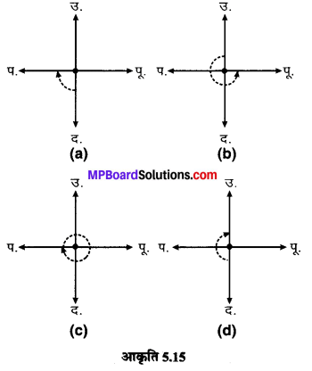
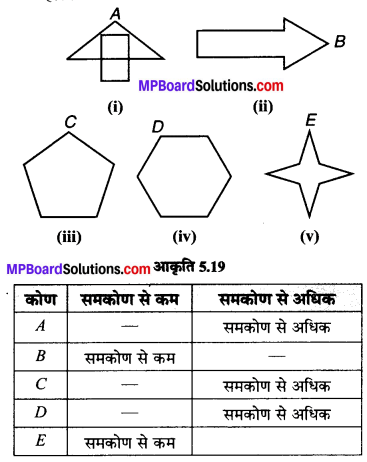
नीचे दी आकृति में दिए प्रत्येक कोण का माप ज्ञात कीजिए (पहले देखकर आकलन कीजिए और फिर चाँदे से मापिए):
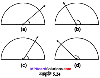
हल :
(a) आकलन से 350° (a) कोण का माप = 40°
(b) आकलन से 120° (b) कोण का माप = 130°
(c) आकलन से 60° (c) कोण का माप = 65°
(d) आकलन से 130° (d) कोण का माप = 135°
![]()
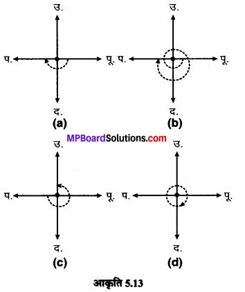
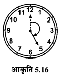
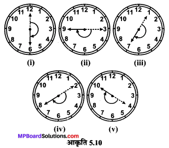
प्रश्न 9.
नीचे दी प्रत्येक आकृति में घड़ी की सुइयों के बीच के कोण का माप ज्ञात कीजिए :
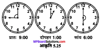
हल :
कोणों की माप
(i) प्रात: 9 : 00 बजे = 90° ;
(ii) दोपहर 1 : 00 बजे = 30° ;
(iii) सायं 6 : 00 बजे = 180°
प्रश्न 10.
खोज कीजिए : दी हुई आकृति में चाँदा 30° दर्शा रहा है। इसी आकृति को एक आवर्धन शीशे (magnifying glass) द्वारा देखिए, क्या यह कोण बड़ा हो जाता है ?
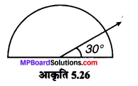
क्या कोण का माप बड़ा हो जाता है ?
उत्तर-
आवर्धन शीशे द्वारा देखने पर कोण के माप में कोई अन्तर नहीं आता है। न तो यह कोण बड़ा होता है और न कोण का माप बड़ा हो जाता है।
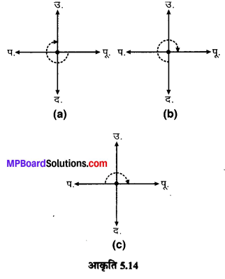
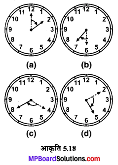
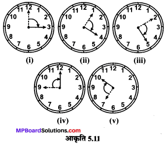
प्रश्न 11.
मापिए और प्रत्येक कोण को वर्गीकृत कीजिए :
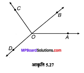
उत्तर-
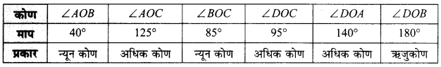
![]()
पाठ्य-पुस्तक पृष्ठ संख्या # 109-110
सोचिए, चर्चा कीजिए एवं लिखिए
प्रश्न 1.
यदि AB ⊥ CD है, तो हमें क्या यह भी कहना चाहिए कि CD ⊥ AB है?
हल :
यदि CD ⊥ AB हो, तो ∠COB = 90° जो कि सत्य है। क्योंकि
AB ⊥ CD
अतः AB ⊥ CD = CD ⊥ AB
अतः हम यह कह सकते हैं कि CD ⊥ AB
प्रश्न 2.
क्या कोई और अक्षर (T अतिरिक्त) भी है, जो लम्बों का उदाहरण है ?
हल :
हाँ, है; अंग्रेजी अक्षर L अन्य अक्षर है जो लम्ब का उदाहरण है।
प्रश्न 3.
एक पोस्टकार्ड को लीजिए। क्या इसके किनारे परस्पर लम्ब हैं ?
उत्तर-
हाँ, पोस्टकार्ड के किनारे परस्पर लम्ब हैं।