MP Board Class 7th Sanskrit Solutions Surbhi Chapter 19 देशहिताय
MP Board Class 7th Sanskrit Chapter 19 अभ्यासः
प्रश्न 1.
एक शब्द में उत्तर लिखो
(क) सिद्धार्थः कस्यां कक्षायां पठति? [सिद्धार्थ किस कक्षा में पढ़ता है?]
उत्तर:
‘सप्तम कक्षायां’
(ख) देशः कस्य तुल्यः अस्ति? [देश किसके समान है?]
उत्तर:
मातृतुल्यः
(ग) “शन्नोवरुणः’ इति कस्याः ध्येयवाक्यम् अस्ति? [‘शन्नो वरुण’ किसका ध्येय वाक्य है?]
उत्तर:
जलसेनायाः
(घ) देशसेवायाः सर्वेषां मार्गाणाम् उद्देश्यं किम्? [देशसेवा के सभी मार्गों का क्या उद्देश्य है?]
उत्तर:
‘देशहितम्’
![]()
(ङ) सिद्धार्थस्य मित्रं कः? [सिद्धार्थ का मित्र कौन है?]
उत्तर:
सुधीशः।
प्रश्न 2.
एक वाक्य में उत्तर लिखो
(क) बालचरः इत्युक्ते किं ज्ञायते? [बालचर कहे जाने से क्या प्रतीत होता है?]
उत्तर:
‘बालचरः’ इति बालानां एका सेवासंस्था अस्ति। [‘बालचर’ नामक बालकों की एक सेवा संस्था है।]
(ख) राष्ट्रियछात्रसेनायाः’ (एन.सी.सी.) ध्येयवाक्यं किम्? [राष्ट्रीय छात्र सेना का ध्येय वाक्य क्या है?]
उत्तर:
राष्ट्रियछात्रसेनायाः (एन.सी.सी.) ध्येयवाक्यं ‘अहं न भवान्’ इति। [राष्ट्रीय छात्र सेना का ध्येय वाक्य “मैं नहीं, आप” है।]
(ग) सेनायाः त्रिविधप्रकाराः के सन्ति? [सेना के तीन भेद कौन से हैं?]
उत्तर:
सेनायाः त्रिविधप्रकाराः सन्ति-जल सेना, वायु सेना, स्थल सेना च। [सेना के तीन भेद हैं-जल सेना, वायु सेना और स्थल सेना।]
(घ) बालचरस्य प्रथमा प्रतिज्ञा का अस्ति? [बालचर की पहली प्रतिज्ञा क्या है?]
उत्तर:
बालचरस्य प्रथमा प्रतिज्ञा अस्ति-‘ईश्वरं स्वदेशं प्रति च कर्त्तव्य पालनं’। [बालचर की पहली प्रतिज्ञा है-ईश्वर और अपने देश के प्रति कर्त्तव्य का पालन करना।]
(ङ) छात्रजीवने देशसेवायाः मार्गों को? [छात्र जीवन में देश सेवा के कौन से दो मार्ग हैं?]
उत्तर:
छात्रजीवने देश सेवायाः मार्गौ–’राष्ट्रीय छात्र सेना’, ‘राष्ट्रीय सेवायोजना’ च। [छात्र जीवन में देशसेवा के दो मार्ग (उपाय) हैं- ‘राष्ट्रीय छात्र सेना’ तथा ‘राष्ट्रीय सेवा योजना’।]
प्रश्न 3.
रेखांकित शब्द के आधार पर प्रश्न बनाओ
(क) ‘सिद्धार्थ:’ सप्तम्यां कक्षायां पठति।
(ख) गणवेशधारिणः वयं बालचराः स्मः।
(ग) “सर्वेषां सहायता” इति द्वितीया प्रतिज्ञा।
(घ) जलसेना जलमार्गात् देशसुरक्षां करोति।
(ङ) बालचरः एकं ग्रामं जनसेवायै गच्छति।
उत्तर:
(क) कः सप्तम्यां कक्षायां पठति?
(ख) गणवेशधारिणः वयं के स्मः?
(ग) ‘सर्वेषां का’ इति द्वितीया प्रतिज्ञा?
(घ) जलसेना कस्मात् देश सुरक्षां करोति?
(ङ) बालचरः एक ग्रामं कस्याथै गच्छति?
![]()
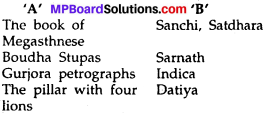
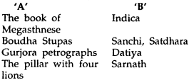
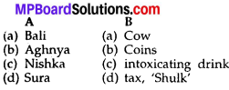
प्रश्न 4.
मिलान करो-
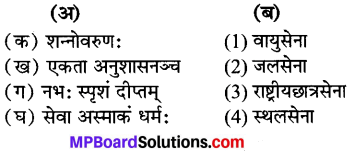
उत्तर:
(क) → (2)
(ख) → (3)
(ग) → (1)
(घ) → (4)
प्रश्न 5.
कोष्ठक से चुनकर वाक्य बनाओ-
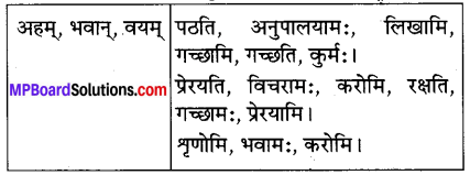
उत्तर:
(क) अहम् लिखामि।
(ख) अहम् गच्छामि।
(ग) अहम् करोमि।
(घ) अहम् प्रेरयामि।
(ङ) भवान् पठति।
(च) भवान् गच्छति।
(छ) भवान् प्रेरयति।
(ज) भवान् रक्षति।
(झ) वयम् अनुपालयामः।
(ब) वयम् कुर्मः।
(ट) वयम् विचरामः।
(ठ) वयम् गच्छामः।
(ड) वयम् भवामः।
(ढ) अहम् शृणोमि।
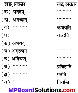
प्रश्न 6.
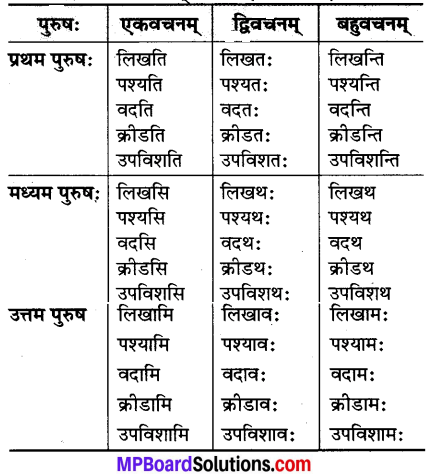
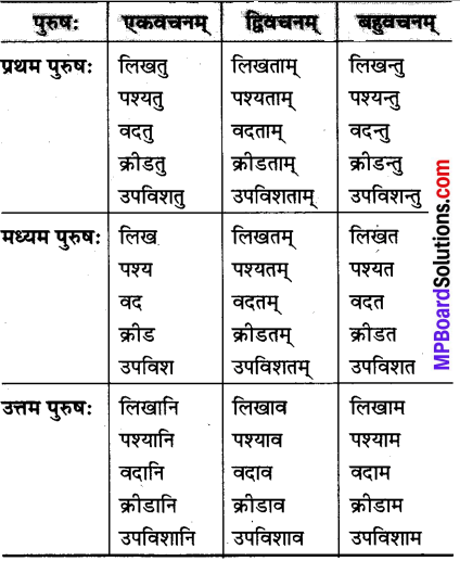
उदाहरण के अनुसार रूप लिखो
धातुएँ :
लिख्, दृश् (पश्य), वद्, क्रीड, उपविश।
लकार :
लट्, लोट् (सभी पुरुष व सभी वचनों में)
उत्तर:
लट् लकार (वर्तमान में)
लोट् लकार (आज्ञायां)
![]()
प्रश्न 7.
कोष्ठक में दिये गये शब्दों से रिक्त स्थानों को पूरा करो
(कक्षायां, ग्रामम्, सेवासंस्था, मातृतुल्यः, सेना, बालचराः, के मार्गाः, ताः प्रतिज्ञाः, मार्गाभ्याम्)
(क) कस्यां ………।
(ख) एकं ……….।
(ग) एका ……….।
(घ) गणवेशधारिणः ………।
(ङ) काः प्रतिज्ञाः ……….।
(च) देशः ……….।
(छ) एताभ्यां ………।
(ज) एषा ……..।
उत्तर:
(क) कक्षायां
(ख) ग्रामम्
(ग) सेवासंस्था
(घ) बालचरा
(ङ) ताः प्रतिज्ञाः
(च) मातृतुल्यः
(छ) मार्गाभ्याम्
(ज) सेना।
देशहिताय हिन्दी अनुवाद
सुधीश: :
मित्र सिद्धार्थ! भवान् कस्यां कक्षायां पठति?
सिद्धार्थः :
अहं सप्तमकक्षायां पठामि। सुधीशः-एतद् वेशं धृत्वा भवान् कुत्र गच्छति?
सिद्धार्थ :
मित्र! पश्यतु मम गणवेशम्। अहं बालचरः। अतः जनसेवायै एक ग्रामं गच्छामि।
सुधीश: :
‘बालचरः’ इत्युक्ते किं ज्ञायते?
सिद्धार्थः :
बालचरः इति बालानां एका सेवासंस्था अस्ति। तस्याः सदस्यः भूत्वा वयं देशसेवां कर्तुं समर्थाः भवामः।
अनुवाद :
सुधीश :
हे मित्र सिद्धार्थ! आप किस कक्षा में पढ़ते हो?
सिद्धार्थ :
मैं सातवीं कक्षा में पढ़ता हूँ। सुधीश-यह वेश धारण करके आप कहाँ जा रहे हो?
सिद्धार्थ :
मित्र! मेरे गणवेश को देखो। मैं बालचर हैं। इसलिए मनुष्यों की सेवा के लिए एक गाँव को जा रहा हूँ।
![]()
सुधीश :
‘बालचर’ इसके कहने से क्या ज्ञात होता है?
सिद्धार्थ :
‘बालचर’ नामक बालकों की एक सेवा संस्था है। उसके सदस्य बनकर हम देश सेवा करने में समर्थ होते हैं।
सुधीश: :
बालचरो भूत्वा भवान् किं किं करोति?
सिद्धार्थः :
गणवेशधारिणः वयं बालचराः सर्वत्र विचरामः। वयं देवालयेषु मेलापकेषु हट्टेषु जनसमूहेषु सामाजिकार्यक्रमेषु भूकम्पादि आपात्कालेषु च उत्साहेन जनानां साहाय्यं कुर्मः। प्रतिज्ञाः अपि अनुपालयामः।
सुधीश: :
काः ताः प्रतिज्ञाः?
सिद्धार्थः :
प्रथमा तु ‘ईश्वरं स्वदेशं प्रति च कर्त्तव्यपालनं’, द्वितीया तावत् ‘सर्वेषां सहायता’ तृतीया प्रतिज्ञा ‘संस्थायाः अनुशासनस्य पालनम्’ इति।
अनुवाद :
सुधीश :
बालचर होकर आप क्या-क्या करते हो?
सिद्धार्थ :
गणवेश धारण किये हुए हम सभी बालचर सर्वत्र घूमते हैं। हम सब मन्दिरों में, मेलों में, हाटों में (पैठ में), मनुष्यों की भीड़ में, सामाजिक कार्यक्रमों में और भूकम्प आदि आपातकाल में उत्साहपूर्वक मनुष्यों की सहायता करते हैं। प्रतिज्ञा का भी पालन करते हैं।
सुधीश :
वह कौन सी प्रतिज्ञा है?
सिद्धार्थ :
पहली (प्रतिज्ञा है) ‘ईश्वर और अपने देश के प्रति कर्त्तव्य का पालन’, दूसरी (प्रतिज्ञा है) ‘सबकी सहायता करना’, तीसरी (प्रतिज्ञा है) ‘संस्था के अनुशासन का पालन करना।’
![]()
सुधीशः :
भवन्तं सेवायै कः प्रेरयति? सिद्धार्थः-देशस्तु मातृतुल्यः। मातृसेवायै सर्वे समानयोग्याः। आत्मप्रेरणया एव देशसेवां कुर्मः।
सुधीशः :
कथमहं देशसेवां कर्तुं शक्नोमि? के ते मार्गाः?
सिद्धार्थ: :
देशसेवायाः बहवः मार्गाः सन्ति। छात्रजीवने ‘राष्ट्रियछात्रसेना (एन.सी.सी.)’ इति। ‘राष्ट्रियसेवायोजना (एन.एस.एस.)’ इति देशसेवामार्गौ। ‘एकता अनुशासनञ्च’ राष्ट्रियछात्रसेनायाः ध्येयवाक्यम् एवञ्च ‘अहं न भवान्’ इति राष्ट्रियसेवायोजनायाः ध्येयवाक्यमस्ति। एताभ्यां मार्गाभ्यां वयं व्यक्तित्वविकासेन सह समाजसेवां देशसेवां च कर्तुं शक्नुमः।
अनुवाद :
सुधीश-आपको सेवा करने के लिए कौन प्रेरणा देता है?
सिद्धार्थ :
देश तो माता के समान है। माता की सेवा के लिए सभी समान रूप से योग्य हैं (सक्षम हैं)। आत्मा से प्राप्त प्रेरणा से ही देश की सेवा करते हैं।
सुधीश :
मैं किस तरह देश सेवा कर सकता हूँ? वे कौन से उपाय हैं?
सिद्धार्थ :
देश सेवा के बहुत से योग्य उपाय हैं। विद्यार्थी जीवन में “राष्ट्रीय छात्र सेना (एन. सी. सी.)” होती हैं। ‘राष्ट्रीय सेवायोजना’ (एन. एस. एस.) देश सेवा के उपाय हैं। ‘एकता और अनुशासन’ राष्ट्रीय छात्र सेना का ध्येय वाक्य ही है और ‘मैं नहीं आप’ भी राष्ट्रीय सेवायोजना का ध्येय वाक्य हैं। इन दोनों उपायों से (मार्गों से) हम सभी व्यक्तित्व विकास के साथ ही समाजसेवा और देश सेवा करने में समर्थ हैं।
सुधीशः :
छात्रजीवनस्य अनन्तरं देशसेवायाः के मार्गाः?
सिद्धार्थ: :
जल-वायु-स्थलसेना इति त्रिविधसेनाप्रकाराः देशसेवायाः एव मार्गाः सन्ति।
सुधीश: :
मित्र! एतासां सेनानां विषये किञ्चित् विवरणं ददातु।
सिद्धार्थ: :
जलसेनायाः ध्येयवाक्यं ‘शन्नोवरुणः’ इति अस्ति। एषा जलमार्गात् देशरक्षां करोति। वायुसेना ‘नभः स्पृशं दीप्तम्’ इति ध्येयवाक्यं स्वीकृत्य आकाशमार्गात् देशं रक्षति। स्थलसेनायाः ध्येयवाक्यं-‘सेवा अस्माकं धर्मः’ इति। एषा स्थलात् देशरक्षणं करोति।
![]()
सुधीश: :
भवतु, ज्ञातं देशहितमार्गाणां विषयेः, किन्तु एतेषु कः भेदः।
सिद्धार्थ: :
न कोऽपि भेदः। एते सर्वे जाति-धर्म-भाषाभेदरहिताः देशसेवायाः विभिन्नाः मार्गाः वर्तन्ते। सर्वेषामुद्देश्यं तु एकम् एव ‘देशहितम्’ इति।
अनुवाद :
सुधीश :
छात्र जीवन के बाद देशसेवा के कौन से उपाय हैं?
सिद्धार्थ :
जल सेना, वायु सेना तथा थल सेना, जो तीन प्रकार की सेना है, (वह भी) देशसेवा के उपाय हैं।
सुधीश :
हे मित्र! इन सभी सेनाओं के विषय में कुछ विवरण दीजिए।
सिद्धार्थ :
‘जल सेना’ का ध्येय वाक्य ‘शन्नोवरुण:’ (वरुण देवता हमारा कल्याण करे) है। यह जलमार्ग से देश की रक्षा करती है। वायुसेना ‘नभः स्पृशं दीप्तम्’ (आकाश प्रकाश से युक्त हो) इस ध्येय वाक्य को स्वीकार करके आकाशमार्ग से देश की रक्षा करती है। स्थल सेना (थल सेना) का ध्येय वाक्य है-‘सेवा (ही) हमारा धर्म है।’ यह स्थल से देश की रक्षा करती है।
सुधीश :
ठीक है, देश की भलाई के मार्गों (उपायों) के विषय में जानकारी मिली। किन्तु इनमें कौन सा भेद है?
सिद्धार्थ :
कोई भी भेद नहीं है। ये सभी जाति-धर्म और भाषा के भेद से रहित देश सेवा के विभिन्न मार्ग (उपाय) हैं। सभी का एक ही उद्देश्य ‘देश की भलाई (कल्याण)’ है।
देशहिताय शब्दार्थाः
धृत्वा = पहनकर। जनसेवायै = लोगों की सेवा के लिए। मेलापकेषु = मेलों में। हट्टेषु = बाजारों में। मातृतुल्यः = माता के समान।