MP Board Class 8th Social Science Solutions Chapter 13 North America-Geographical Features
MP Board Class 8th Social Science Chapter 13 Text Book Exercise
Choose the correct option of the following
Mp Board Class 8 Social Science Solution Chapter 13 Question 1.
Due to the meeting of which current near New Found-land thick fog develops?
(a) Gulf stream and Alaska current.
(b) Gulf stream and California.
(c) Gulf stream and Labrador current.
(d) Labrador and Alaska current.
Answer:
(c) Gulf stream and Labrador current.
Mp Board Class 8 Social Science Chapter 13 Question 2.
Which of the following climate is known for winter rain?
(a) Desert climate
(b) Mediterranean climate
(c) Tundra climate
(d) Equatorial climate
Answer:
(c) Tundra climate
MP Board Class 8th Social Science Chapter 13 Very Short Answer Type Questions
North America Geographical Features Class 8 Question 1.
Write the latitude and longitude expense of North America?
Answer:
North America is situated in Northern Hemisphere. North America lies entirely in the Northern Hemisphere. It lies between 10° N and 70°N latitudes and 50° W and 170° W longitudes.
Class 8 Social Science Chapter 13 Question 2.
Which is the highest mountain peak of North America?
Answer:
Mt. McKinley is the highest mountain peak of North America. It is 6194 meters above sea level.
Class 8 Social Science Chapter 13 Mp Board Question 3.
Write the names of great lakes of Northern America?
Answer:
- Superior
- Michigan
- Hurin
- Eris
- Ontario are famous great lakes of Northern America.
North America Extends From East To West Question 4.
Name the four ocean currents which influence the climate of North America?
Answer:
Gulf Stream, Labrador Current, California Current and the Alaska Current are the four currents which influence the climate of’ North America.
Mp Board Class 8 Science Solution Chapter 13 Question 5.
Write two qualities of Coniferous forests?
Answer:
- In this area mostly the land is covered with snow so big trees can not grow.
- The top of the trees which are in one shape cannot hold the snow and it falls down on the earth and so the branches are stooped. Spruce, pine, larch, oak and redwood tree are main trees.
MP Board Class 8th Social Science Chapter 13 Short Answer Type Questions
Mp Board Class 8 Science Chapter 13 Question 1.
Write names of three plateaus of North America with their locations.
Answer:
- In the east lies Rocky mountain range, Sierra Nevada in central and coastal range in western area. Among these mountains ranges there is inter-mountain Plateau Great Basin. The Plateau of Colorado lies in South of Great Britain.
- Eastern Highlands include the Appalachian Mountains and their extensions. In the east there is Labrador plateau.
- To the South east of the Eastern Highlands lies the plateau of Appalachian. These ancient plateaus are deposits of minerals.
Question 2.
Write the reasons of diversities in the vegetation of North America.
Answer:
Climate and physical features have great influence on natural vegetation, as the origin and growth both depends on the climate. North America is a continent where barring Mediterranean vegetation, all types of vegetation of world are found. Due to diversity in climate and uneven distribution in rainfall, diversity is seen in vegetation also. North America is rich in forest wealth.
Question 3.
Write the three characteristics of Mediterranean vegetation?
Answer:
The Western Central areas have Mediterranean vegetation. Here trees of Oaks, Cheer, Olive, Redwood, Cork and juicy fruits grow in larger number. The valley of California is famous for fruits production. The bark of trees and leaves are thick, soft and wide fine trees are thorny which protects trees from dying
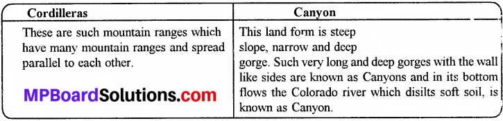
Question 4.
What is the difference be Cordilleras and Canyon?
Answer:
MP Board Class 8th Social Science Chapter 13 Long Answer Type Questions
Question 1.
Write the names of North America’s physical features and define in brief?
Answer:
Major Physical Divisions of North America:
North America may be divided into three major physical divisions. They are Western Cordilleras the Eastern Highlands and the Central Lowlands.
1. The Western Cordilleras:
- The vast mountainous area in the western part of the continent is known as Western Cordillera.
- They extend from north to south along the entire length of the continent.
- The highest peak of the Western Cordillera is Mt. Mckinley.
- Most of the rivers of North America rise in Western Cordilleras.
- These mountains consist of several parallel ranges. The Rocky Mountain is the most prominent among them.
- The coastal range and the Sierra Nevada are the two other ranges.
- The plateaus between these range are called inter montane plateau. Colorado plateau is an important inter montane plateau of North America.
- There are many active volcanoes in Alaska and Mexico.
2. The Eastern Highlands:
- These highlands consist of Appalachian Mountains and their extensions in Labrador and New Found land.
- They are much older. These old mountains have been worn down by agents of gradation for the long period of time. They are now very low in height.
3. The Great Central Plains:
- They lie between the Western Cordillera and the Eastern Highlands.
- They have two distinct parts:
- In the north it is occupied by the Canadian Shield and the basin of the river Mackenzie,
- The Central and Southern part is very low and flat basin of the river Missouri-Mississippi.
- The Great Central Plain has a very fertile river basin.
- There is Hudson Bay surrounding by the Canadian Shield.
- To the south of the Canadian Shield are five great lakes of fresh water. They are Lake Superior, Lake Huron,
- Lake Erie, Lake Michigan and Lake Ontario.
- The famous Niagara falls lie between Lake Erie and Lake Ontario.
- River St. Lawrence is an important river of this region.
Question 2.
Mention about the Coniferous forest and wildlife?
Answer:
In the south of Tundra, the wide stretch of last to west experiences very cold winter and the summer is normal. In this entire area the coniferous forest belts are found these forests contain trees of Chir, Larche, Spruce and Fir. The woods of these forests are very soft and they are used as pulp for paper and furniture. These forests have wild life like bear, polar bear, fox, wolfs, rabbits and stags.
Question 3.
Elaborate the factors that affect climate of North America?
Answer:
1. These are four factors which affect the climate of North America:
The latitudinal expansion of continents. North America extends from the Tropics in the South to the Sub-tropical in the Central and South to the Arctic in the North. Therefore, the southern part is comparatively hot, the central part alternatively hot and cold and the northern part very cold. Most of the North America is in Temperate Zone.
2. Surface diversities:
In the West cordillera holds the Western winds and brings excess rain while the east slope gets very less rain due to rain shadow area. That is why the plains of Prahie receive very less rain but as we move from the plains of Praries to east, southeast plateaus and mountains, the rains increase gradually. In the north of the continent it rains in the form of snowfall and it is less because this area is low-lying area. .
3. Permanent winds:
In the west Cordilleras and high lands in the east, both extending from North to South have very vast plain. The polar winds from north in winter and the hot summer winds from south affects the vast plains. Therefore, it is cold in winter and hot in the summer. The southern and the southeastern coasts of the continent come in the region of the trade winds and the north-western coast falls in the region of the westerlies.
These parts therefore receive heavy rains. The westerlies start blowing over Western California. This brings winter rains to California. The Monsoon winds affect the Mexican region. Therefore, it receives rains in the summer. Due to trade winds the Gulf of Mexico and south-eastern Coastal area receive the rains throughout the year.
4. Effect of Currents:
The hot and cold currents flowing near coasts affect the climate mostly. The Gulf Stream flows along the south-eastern coast of the continent and the Alaska current flows along the north western coast. The cold Labrador current passes by the northeastern part and the California current flows along the south-western part. So the climate is very cold. Near New Found land the cold and hot currents meet and this causes dense fig. So it is very helpful for fishing. This area is known as fishing banks.
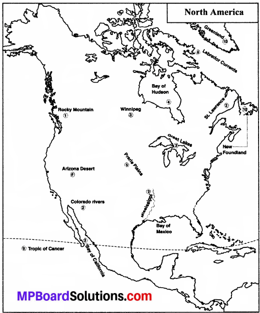
Project Work
Show the following in the map of North America.
- All pachian Mountain, Rocky Mountain.
- Mississippi, St Lawrence, Colorado rivers.
- Great Lakes and Winnipeg.
- Mexico, Hudson and California.
- Prairie plains.
- Arizona Desert.
- Plataea of Labrador.
- Gulf-stream, Labrador Currents.
- Tropic of Cancer.
- Western island, Greenland, New Found land.
Answer: