MP Board Class 6th Social Science Solutions Chapter 6 Globe and Map
MP Board Class 6th Social Science Chapter 6 Globe and Map Text Book Exercise
MP Board Class 6th Social Science Chapter 6 Globe and Map Short Answer Type Questions
Question 1.
Question (a)
What is a globe?
Answer:
Globe is a three dimensional model of earth or sphere, which gives us the correct idea of the shape of the earth.
Question (b)
What information can we get from a globe? Write any five?
Answer:
The following information we can get from a globe:
- The earth is a bit flat at the poles.
- The shape of earth is spheroid.
- The earth is not straight on its axis but a little tilted.
- The globe shows the location of oceans, islands, continents, main mountains and countries, etc.
- The characteristics of the horizontal and vertical lines drawn on the globe.
![]()
Question (c)
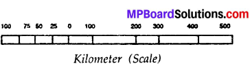
What is a scale?
Answer:
1. The scale of the map is a measuring line with the help of which correct distance between various points on a map can be measured. The scale of map is, a ratio between any two points on the maps and actual distance on the land.
2. It can be a millimetre, a centimetre or an inch to represent a kilometre, a hundred kilometre or a thousand kilometre or even still larger distances. On some maps the scale is not given as a line but is mentioned in words. For instance, it may be given as 1 centimetre = 100 kilometre
3. It means that one centimetre on the map is equal to one hundred kilometre on the ground.
MP Board Class 6th Social Science Chapter 6 Globe and Map Long Answer Type Questions
Question 2.
Question (a)
What should we know to read a map? Explain any two.
Answer:
A map can be read and understand as a book is read and information is gathered from it. A map can be made and read on four basic points. These are:
- Symbol
- Direction
- Headings
- Scale
1. Symbol:
It is the third important component of any map. When an area or locality is shown on a map, it is not possible to show various features, e.g., roads, building, trees, railway lines in their actual shape and size. To overcome this difficulty, the features are shown by different symbols. The use of symbols saves space and a lot of information can be given in a single map.
Various colours in maps are chosen for the same purpose. All over the world there has been some kind of agreement regarding the use of symbols and colours. The symbols used all over the world in various maps are called conventional symbols.
2. Direction:
It is another very important component of any map. A map has four directions i.e., north, south, east and west. While knowing any one direction on map we fan find all the remaining directions.
3. Headings:
Heading is the one of the component of read a map. “Structure” to their code that identifies main headings and subheadings. Headings Map creates a visual heading structure of the webpage by generating an index or ‘map’ of the headings created by the author.
![]()
4. Scale:
The scale of the map is a measuring line with the help of which correct distance between various points on a map can be measured. The scale of map is, a ratio between any two points on the maps and actual distance on the land.
5. It can be a millimetre, a centimetre or an inch to represent a kilometre, a hundred kilometre or a thousand kilometre or even still larger distances. On some maps the scale is not given as a line but is mentioned in words. For instance, it may be given as 1 centimetre = 100 kilometre
6. It means that one centimetre on the map is equal to one hundred kilometre on the ground.
Question (b)
Why are maps made?
Answer:
Maps are made to study any part of earth, about our country, our” state, the district in which we live or the town or the village etc.
The importance of a Globe in Geography:
- To understand the phenomena related to the shape, inclination and movement of the planet and earth.
- To understand the distribution of land and water on the earth.
- To understand the extent of oceans and continents and their position on earth.
- The globe can be rotated as the earth rotates on its axis.
The Importance of a Map in Geography:
- Map helps us to find the exact location of the countries, states of the world.
- Maps shows the roads and boundries of any state; district, town, city and village.
- Maps showing physical features of the earth such as land forms of different elevations.
![]()
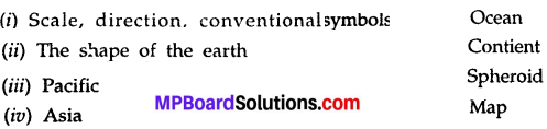
Question 3.
Fill in the blanks choosing the correct option given:
(seven, four, globe, map, blue)
- The drawing of any part of the earth on a plane surface is called …………….
- The model of the earth is called …………….
- There are ……………… continents and oceans on earth.
- The colour ………………… is seen most on the globe.
Answer:
- map
- globe
- seven, four
- blue
Question 4.
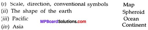
Match the column.
Answer:
Question 5.
Choose the correct names of the symbols given in the bracket and write in the blanks given in front of the symbol:
(district border, state border, railway line, metal road, well)
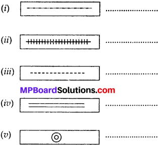
Answer:
- State border
- Railway line
- District border
- Well
Question 6.
The scale in a map is 1 cm = 20 km. What will be the actual distance shown in the map by 4 cm?
Answer:
- Here, 1 cm = 20 km
- ∴ The actual distance of 4 cm = 4 x 20 km = 80 km
Thus, the actual distance shown in the map by 4 cm is 80 km.
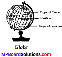
Question 7.
Draw the picture of a globe below and show, equator, tropic of cancer and tropic of capricorn.
Answer:
Project Work
Question 1.
Make a list of continents, ocean, seas and islands using a globe or the map of the world. With the help of a globe write down the names of the main latitudes between the north and the south pole.
Answer:
List of Continents:
- North America
- South America
- Asia
- Europe
- Africa
- Australia
- Antarctica
List of Oceans:
- Pacific Ocean
- Atlantic Ocean
- Indian Ocean
- Arctic Ocean
List of Seas:
1. Arabian sea
List of Islands:
1. Andaman and Nicobar Islands.